|
search place name
|
||
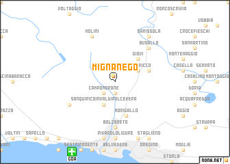
Mignanego (Italy)Mignanego is a town in Italy. An overview map of the region around Mignanego is displayed below.
regional and 3d topo map of Mignanego, Italy ::
Mignanego airports ::
The nearest airport is GOA - Genoa Genova Sestri, located 12.5 km south west of Mignanego.
Other airports nearby include QPZ - Piacenza (78.7 km north east), ALL - Albenga (80.5 km south west), CUF - Levaldigi (101.5 km west), LIN - Milan Linate (107.4 km north), Nearby towns ::
Pontedecimo (1.9km south) //
Campomorone (2.3km south west) //
Serra Riccò (3.2km north east) //
San Quirico in Val di Polcevera (3.9km south) //
Giovi (4.6km north east) //
Montanesi (4.4km north east) //
Morigallo (5.7km south) //
Bolzaneto (7.4km south) //
Busalla (6.8km north east) //
Molini (7.9km north) //
San Carlo (6.5km south west) //
Sarissola (8.4km north east) //
[all distances 'as the bird flies' and approximate]  Places with similar names to Mignanego, Italy ::
// Moknawng (MM)
// Magnangoy (PH)
// Magnuang (PH)
// Maquineng (PH)
// Meganeng (ZA)
// Mikhnenki (RU)
// Maokininga (TD)
// Muakanangu (CD)
// Makéninga (CG)
// Macanang (ID)
Disclaimer :: Information on this page comes without warranty of any kind |
||
|
Where is Mignanego? Elevation and coordinates ::
Latitude (lat): 44°31'0"N Longitude (lon): 8°54'0"E
Elevation (approx.): 333m (map arrows pan, magnifying glasses zoom) |
||
|
Visiting Mignanego? Hotel/Accommodation ::
Book a hotel in Mignanego Travel Guide ::
Buy a travel guide for Italy rental cars ::
car rental offers GPS waypoint ::
download a GPX waypoint (PoI) of Mignanego for your GPS receiver
|
||