|
search place name
|
||
Pilcante (Italy)Pilcante is a town in Italy. An overview map of the region around Pilcante is displayed below.
regional and 3d topo map of Pilcante, Italy ::

Pilcante airports ::
The nearest airport is VRN - Villafranca, located 41.9 km south of Pilcante.
Other airports nearby include VIC - Vicenza (47.7 km south east), VBS - Montichiari (63.3 km south west), QPA - Padova (79.1 km south east), BZO - Bolzano (81.5 km north), Nearby towns ::
Camarlotti (2.3km north east) //
Ala (2.3km south east) //
Prada (4.5km north west) //
Vo Sinistro (4.5km south west) //
Crosano (5.7km north) //
Muravalle (4.3km south east) //
Brentonico (6.1km north west) //
Serravalle allʼAdige (6.1km north east) //
Avio (5.4km south west) //
Tierno (7.4km north) //
[all distances 'as the bird flies' and approximate] 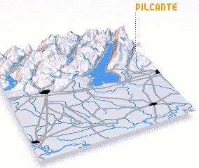 Places with similar names to Pilcante, Italy ::
// Polcanto (IT)
// Pālaikānda (BD)
// Pālikānda (BD)
// Pilikondi (CG)
// Pālkonda (IN)
// Pallikondai (IN)
// Pallekanda (LK)
// Pallekanda (LK)
// Pallekanda (LK)
// Pallekanda (LK)
Disclaimer :: Information on this page comes without warranty of any kind |
||
|
Where is Pilcante? Elevation and coordinates ::
Latitude (lat): 45°46'0"N Longitude (lon): 10°59'0"E
Elevation (approx.): 825m (map arrows pan, magnifying glasses zoom) |
||
|
Visiting Pilcante? Hotel/Accommodation ::
Book a hotel in Pilcante Travel Guide ::
Buy a travel guide for Italy rental cars ::
car rental offers GPS waypoint ::
download a GPX waypoint (PoI) of Pilcante for your GPS receiver
|
||