|
search place name
|
||
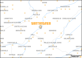
SantʼAndrea (Italy)SantʼAndrea is a town in Italy. An overview map of the region around SantʼAndrea is displayed below.
regional and 3d topo map of SantʼAndrea, Italy ::
SantʼAndrea airports ::
The nearest airport is BLQ - Bologna, located 42.6 km north west of SantʼAndrea.
Other airports nearby include FRL - Forli (45.6 km east), FLR - Firenze (47.8 km south west), RMI - Rimini (90.8 km east), PSA - Pisa (104.8 km south west), Nearby towns ::
Castel del Rio (1.9km north) //
Cestina (2.3km south east) //
Moraduccio (2.3km south west) //
Tirli (4.6km south west) //
Rosana (5.6km south) //
Sommorio (4.4km south east) //
Carseggio (5.7km north) //
Pezzolo (5.7km north) //
Giugnola (5.4km north west) //
Mantigno (7.4km south) //
Sassoleone (7.5km north) //
Rapezzo (6.8km south west) //
Posseggio (6.5km north east) //
Castagnara (6.5km north west) //
Palazzuolo sul Senio (8.4km south east) //
Fontanelice (8.4km north east) //
Casoni di Romagna (9.1km north west) //
[all distances 'as the bird flies' and approximate]  Places with similar names to SantʼAndrea, Italy ::
// Santana do Ouro (BR)
// Santo André (BR)
// Santo André (BR)
// Santo André (BR)
// Santo André (BR)
// Santo André (BR)
// Santo André (BR)
// Santo André (BR)
// Santo André (BR)
// Saint Andrew (US)
Disclaimer :: Information on this page comes without warranty of any kind |
||
|
Where is SantʼAndrea? Elevation and coordinates ::
Latitude (lat): 44°11'0"N Longitude (lon): 11°30'0"E
Elevation (approx.): 279m (map arrows pan, magnifying glasses zoom) |
||
|
Visiting SantʼAndrea? Hotel/Accommodation ::
Book a hotel in SantʼAndrea Travel Guide ::
Buy a travel guide for Italy rental cars ::
car rental offers GPS waypoint ::
download a GPX waypoint (PoI) of SantʼAndrea for your GPS receiver
|
||