|
search place name
|
||
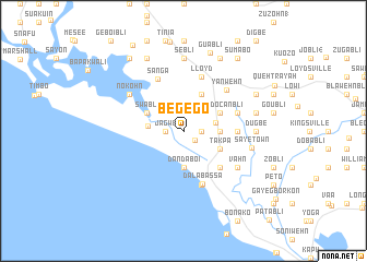
Begego (Grand Bassa, Liberia)Begego is a town in the Grand Bassa region of Liberia. An overview map of the region around Begego is displayed below.
regional and 3d topo map of Begego, Liberia ::
Begego airports ::
The nearest airport is ROB - Monrovia Roberts Intl, located 21.9 km north west of Begego.
Other airports nearby include MLW - Monrovia Spriggs Payne (62.4 km west), Nearby towns ::
Guotobli (1.5km south east) //
Ben Loganbli (2) (1.8km east) //
Whenzohn (1.8km west) //
Jagwe (1.8km west) //
Kro Town (2.5km north west) //
Ben Loganbli (3.3km east) //
Bakibli (3.7km west) //
Dandaboi (3.7km south) //
Saye (3.7km east) //
Takpa (4.1km south east) //
Noyu (4.1km south east) //
Pendocanbli (4.1km north east) //
Okaibli (4.1km north east) //
Swabli (4.1km north west) //
Bawehn (5.2km south east) //
Audrichbli (5.5km east) //
Dala Bassa (5.8km south) //
Bwabli (5.9km south) //
Lloyd (5.9km north) //
Nua (5.8km east) //
Sanga (5.9km north west) //
Yanwehn (6.1km north east) //
Vahn (6.7km south east) //
Nokohn (6.7km north west) //
Saye Town (7.1km east) //
Dugbe (7.4km east) //
Sebli (7.4km north) //
Kpokon (7.4km north) //
Barclayville (4) (7.4km north) //
[all distances 'as the bird flies' and approximate]  Places with similar names to Begego, Liberia ::
Disclaimer :: Information on this page comes without warranty of any kind |
||
|
Where is Begego? Elevation and coordinates ::
Latitude (lat): 6°5'0"N Longitude (lon): 10°14'0"W
Elevation (approx.): 18m (map arrows pan, magnifying glasses zoom) |
||
|
Visiting Begego? Hotel/Accommodation ::
Book a hotel in Begego Travel Guide ::
Buy a travel guide for Liberia rental cars ::
car rental offers GPS waypoint ::
download a GPX waypoint (PoI) of Begego for your GPS receiver
|
||