|
search place name
|
||
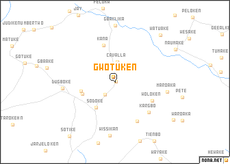
Gwotuken (Maryland, Liberia)Gwotuken is a town in the Maryland region of Liberia. An overview map of the region around Gwotuken is displayed below.
regional and 3d topo map of Gwotuken, Liberia ::
Gwotuken airports ::
The nearest airport is SPY - San Pedro, located 134.1 km east of Gwotuken.
Other airports nearby include DJO - Daloa (253.4 km north east), Nearby towns ::
Bawolobo (0.1km east) //
Rock Town (2.7km south west) //
Cavalla (3.3km north) //
Sodoke (5.2km south west) //
Glofaken (5.7km west) //
Camp King (5.7km west) //
Kana (6.2km north) //
Woloken (6.8km south east) //
Tyiaken (7.4km south east) //
Kargbo (7.4km south east) //
Dugboke (8.6km west) //
Maroaka (8.6km east) //
Wissikan (8.8km south) //
Watuake (10.7km north east) //
Sotike (11.5km south west) //
[all distances 'as the bird flies' and approximate]  Places with similar names to Gwotuken, Liberia ::
// Kwiatków Nowy (PL)
// Kawadgaon (IN)
// Kwadakin (NG)
// Kywedegon (MM)
// Gwedaukkan (MM)
// Gwedaukkon (MM)
// Gwedaukkon (MM)
// Gwedaukkon (MM)
// Gwedaukkon (MM)
// Gwedaukkon (MM)
Disclaimer :: Information on this page comes without warranty of any kind |
||
|
Where is Gwotuken? Elevation and coordinates ::
Latitude (lat): 4°57'47"N Longitude (lon): 7°51'0"W
Elevation (approx.): 141m (map arrows pan, magnifying glasses zoom) |
||
|
Visiting Gwotuken? Hotel/Accommodation ::
Book a hotel in Gwotuken Travel Guide ::
Buy a travel guide for Liberia rental cars ::
car rental offers GPS waypoint ::
download a GPX waypoint (PoI) of Gwotuken for your GPS receiver
|
||