|
search place name
|
||
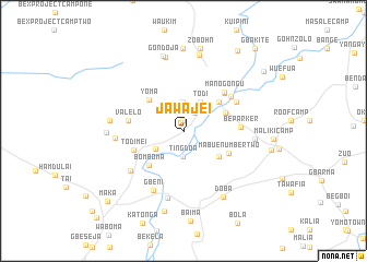
Jawajei (Grand Cape Mount, Liberia)Jawajei is a town in the Grand Cape Mount region of Liberia. An overview map of the region around Jawajei is displayed below.
regional and 3d topo map of Jawajei, Liberia ::
Jawajei airports ::
The nearest airport is MLW - Monrovia Spriggs Payne, located 84.9 km south of Jawajei.
Other airports nearby include ROB - Monrovia Roberts Intl (108.2 km south east), Nearby towns ::
Pando (1.1km north) //
Perazoi (2.2km north east) //
Ting Doa (2.7km south) //
Freetown (2.9km north) //
Todi (3.4km north east) //
Gbako (3.4km south west) //
Kaba Senod (4.5km south east) //
Sembe (4.6km north east) //
Sergeant Konnerʼs Camp (4.6km north east) //
Yoma (4.7km north west) //
Bomboma (4.9km south west) //
Mabue Number Two (5.1km south east) //
Todimei (5.4km west) //
Lofa Bridge (5.7km north east) //
Manogongu (5.7km north east) //
Valelo (5.7km west) //
Be Parker (5.8km east) //
Wuemaww (5.9km north east) //
Liswimco Camp (6.2km north east) //
Gbeni (6.8km south west) //
Gheta Farm (6.8km south west) //
Bamakave (6.9km west) //
Besaki (7.0km south) //
Be Johnson (7.3km east) //
Mambo Village (7.5km west) //
Begondo (7.7km north) //
Doba (7.8km south east) //
Wuese (7.8km west) //
Gondoja (7.9km north) //
[all distances 'as the bird flies' and approximate]  Places with similar names to Jawajei, Liberia ::
Disclaimer :: Information on this page comes without warranty of any kind |
||
|
Where is Jawajei? Elevation and coordinates ::
Latitude (lat): 7°2'26"N Longitude (lon): 10°54'57"W
Elevation (approx.): 86m (map arrows pan, magnifying glasses zoom) |
||
|
Visiting Jawajei? Hotel/Accommodation ::
Book a hotel in Jawajei Travel Guide ::
Buy a travel guide for Liberia rental cars ::
car rental offers GPS waypoint ::
download a GPX waypoint (PoI) of Jawajei for your GPS receiver
|
||