|
search place name
|
||
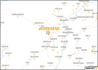
Jenne Sese (Grand Cape Mount, Liberia)Jenne Sese is a town in the Grand Cape Mount region of Liberia. An overview map of the region around Jenne Sese is displayed below.
regional and 3d topo map of Jenne Sese, Liberia ::
Jenne Sese airports ::
The nearest airport is MLW - Monrovia Spriggs Payne, located 79.5 km south of Jenne Sese.
Other airports nearby include ROB - Monrovia Roberts Intl (107.4 km south east), Nearby towns ::
Mbaloma (0.8km south east) //
Jene Brown (1.7km north west) //
Maka (1.8km north east) //
Waboma (3.0km south east) //
Gbeseja (3.5km south) //
Tai (3.6km north west) //
Berry Farm (3.7km south) //
Willija (4.1km south east) //
Hamdulai (5.2km north west) //
Bleng (5.2km north west) //
Katonga (5.3km east) //
Gbesseh (5.4km south) //
Gheta Farm (5.7km north east) //
Tomasja (5.9km south) //
Kuija (5.9km south) //
Mana (5.9km south) //
Yongaja (6.0km south) //
Gbeni (6.6km east) //
Bekela (6.8km south east) //
Sacky Town (6.8km east) //
Dieyili (7.1km north west) //
Be Momo Saki (7.4km east) //
Gbateka (7.5km south east) //
Bomboma (7.5km north east) //
Todimei (7.5km north east) //
Thomas Town (7.7km south east) //
Besaki (7.8km east) //
Sindo (7.8km south east) //
Bamakave (7.9km north) //
[all distances 'as the bird flies' and approximate]  Places with similar names to Jenne Sese, Liberia ::
Disclaimer :: Information on this page comes without warranty of any kind |
||
|
Where is Jenne Sese? Elevation and coordinates ::
Latitude (lat): 6°58'0"N Longitude (lon): 11°0'0"W
Elevation (approx.): 98m (map arrows pan, magnifying glasses zoom) |
||
|
Visiting Jenne Sese? Hotel/Accommodation ::
Book a hotel in Jenne Sese Travel Guide ::
Buy a travel guide for Liberia rental cars ::
car rental offers GPS waypoint ::
download a GPX waypoint (PoI) of Jenne Sese for your GPS receiver
|
||