|
search place name
|
||
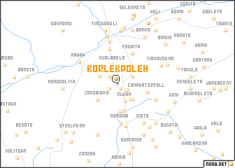
Korlekpoleh (Bong, Liberia)Korlekpoleh is a town in the Bong region of Liberia. An overview map of the region around Korlekpoleh is displayed below.
regional and 3d topo map of Korlekpoleh, Liberia ::
Korlekpoleh airports ::
The nearest airport is ROB - Monrovia Roberts Intl, located 65.1 km south of Korlekpoleh.
Other airports nearby include MLW - Monrovia Spriggs Payne (72.9 km south west), Nearby towns ::
Zuwolota (0.9km south east) //
Vaanita (0.9km south east) //
Botota (0.9km south east) //
Njebele (0.9km south east) //
Camp Moritz (1.5km south west) //
Zwiata (1.7km south east) //
Mulia (1.8km north west) //
Waimu (2.6km north east) //
Nijian (3.0km south) //
Muligua (3.1km north west) //
Bong Town (3.1km south east) //
Kuala Bola (3.2km north) //
Koinda (3.3km north west) //
Zalaimu (3.5km south east) //
Zangbiama (4.0km south west) //
Laa (4.4km south) //
Luula (4.4km south) //
Camp Waterfall (4.9km east) //
Willieta (4.9km north east) //
Neye (4.9km north east) //
Fodaita (5.4km north east) //
Sumota (5.7km north) //
Maniama (6.3km south) //
Johnta (6.3km south) //
Bagoleta (6.6km south east) //
Lomamita (6.8km south) //
Gaigbelei (6.9km north) //
Mawah (7.0km north west) //
Siata (7.5km south east) //
[all distances 'as the bird flies' and approximate]  Places with similar names to Korlekpoleh, Liberia :: Disclaimer :: Information on this page comes without warranty of any kind |
||
|
Where is Korlekpoleh? Elevation and coordinates ::
Latitude (lat): 6°49'22"N Longitude (lon): 10°22'17"W
Elevation (approx.): 148m (map arrows pan, magnifying glasses zoom) |
||
|
Visiting Korlekpoleh? Hotel/Accommodation ::
Book a hotel in Korlekpoleh Travel Guide ::
Buy a travel guide for Liberia rental cars ::
car rental offers GPS waypoint ::
download a GPX waypoint (PoI) of Korlekpoleh for your GPS receiver
|
||