|
search place name
|
||
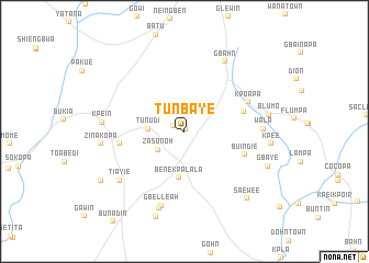
Tunbaye (Nimba, Liberia)Tunbaye is a town in the Nimba region of Liberia. An overview map of the region around Tunbaye is displayed below.
regional and 3d topo map of Tunbaye, Liberia ::
Tunbaye airports ::
The nearest airport is MJC - Man, located 158.0 km east of Tunbaye.
Other airports nearby include ROB - Monrovia Roberts Intl (177.6 km south west), MLW - Monrovia Spriggs Payne (213.2 km south west), Nearby towns ::
Korsein (0.2km north) //
Gbaipa (1.2km north west) //
Zasonoh (3.3km south west) //
Tunudi (3.7km west) //
Benekpalala (4.8km south) //
Weinten (6.3km east) //
Buindie (6.6km east) //
Boyi (6.7km west) //
Kpoapa (7.1km north east) //
Gbelleah (7.9km south) //
Wala (8.0km east) //
Gbahn (8.2km north east) //
Tieyi (8.2km south) //
Tiayie (8.3km south west) //
Kpein (8.3km west) //
Zinakopa (8.5km west) //
Blumo (8.7km east) //
Kpee (8.8km east) //
Gbaye (9.1km south east) //
Zaou (9.2km south) //
Saewee (9.3km south east) //
Komopa (9.8km south west) //
[all distances 'as the bird flies' and approximate] 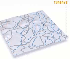 Places with similar names to Tunbaye, Liberia ::
Disclaimer :: Information on this page comes without warranty of any kind |
||
|
Where is Tunbaye? Elevation and coordinates ::
Latitude (lat): 7°5'41"N Longitude (lon): 9°0'25"W
Elevation (approx.): 261m (map arrows pan, magnifying glasses zoom) |
||
|
Visiting Tunbaye? Hotel/Accommodation ::
Book a hotel in Tunbaye Travel Guide ::
Buy a travel guide for Liberia rental cars ::
car rental offers GPS waypoint ::
download a GPX waypoint (PoI) of Tunbaye for your GPS receiver
|
||