|
search place name
|
||
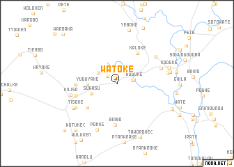
Watoke (Maryland, Liberia)Watoke is a town in the Maryland region of Liberia. An overview map of the region around Watoke is displayed below.
regional and 3d topo map of Watoke, Liberia ::
Watoke airports ::
The nearest airport is SPY - San Pedro, located 112.8 km east of Watoke.
Other airports nearby include DJO - Daloa (254.1 km north east), Nearby towns ::
Yeloke (1.9km north west) //
Wortuke (2.6km east) //
Wuduke (2.8km east) //
Hewake (3.4km north west) //
Suwasu (4.4km west) //
Yuduyake (4.7km west) //
Kaloke (5.8km north east) //
Konoso (6.1km south west) //
Bayake (6.6km west) //
Biabo (6.6km south) //
Kawalake (6.9km west) //
Kronowodoken (7.5km north east) //
Gibsons Villa (7.5km east) //
Tisoke (7.6km south west) //
Kiliso (7.6km west) //
Kaloken (8.0km south west) //
Pomke (8.1km south west) //
New Road Town (8.4km east) //
Nyaake (8.7km east) //
Yeboke (8.7km north) //
Kodeke (8.7km east) //
Taworoke (2) (9.4km south east) //
Kpaniake (9.7km south east) //
Suwroken (9.8km north east) //
Wutuke (2) (10.0km south west) //
Klaesu (11.3km south west) //
Waroaka (11.7km north west) //
[all distances 'as the bird flies' and approximate]  Places with similar names to Watoke, Liberia ::
Disclaimer :: Information on this page comes without warranty of any kind |
||
|
Where is Watoke? Elevation and coordinates ::
Latitude (lat): 4°50'5"N Longitude (lon): 7°40'26"W
Elevation (approx.): 81m (map arrows pan, magnifying glasses zoom) |
||
|
Visiting Watoke? Hotel/Accommodation ::
Book a hotel in Watoke Travel Guide ::
Buy a travel guide for Liberia rental cars ::
car rental offers GPS waypoint ::
download a GPX waypoint (PoI) of Watoke for your GPS receiver
|
||