|
search place name
|
||
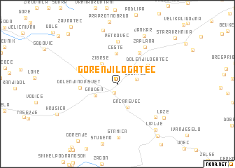
Gorenji Logatec (Cankova-Tišina, Slovenia)Gorenji Logatec is a town in the Cankova-Tišina region of Slovenia. An overview map of the region around Gorenji Logatec is displayed below.
regional and 3d topo map of Gorenji Logatec, Slovenia ::
Gorenji Logatec airports ::
The nearest airport is LJU - Ljubliana Ljubljana, located 40.4 km north east of Gorenji Logatec.
Other airports nearby include TRS - Ronchi De Legionari Ronchi Dei Legionari (57.1 km west), POW - Portoroz (66.3 km south west), RJK - Rijeka (82.1 km south), KLU - Klagenfurt (Worthersee Intl) (82.4 km north), Nearby towns ::
Kalce (1.4km south) //
Logatec (2.2km east) //
Gruden (3.0km south west) //
Grčarevec (3.8km south) //
Žibrše (3.7km north west) //
Česte (4.9km north) //
Dolenji Logatec (4.4km north east) //
Dolenji Novi Svet (4.2km west) //
Jerinov Grič (5.5km north east) //
Hotedršica (5.0km north west) //
Petkovec (6.8km north) //
Zaplana (6.6km north east) //
Jakovica (6.7km south east) //
Strmica (8.5km south) //
Jankar (8.2km north) //
Rovte (8.8km north) //
Laze (7.4km south east) //
Liplje (8.3km south east) //
Planina (9.3km south east) //
Potok (9.7km north west) //
[all distances 'as the bird flies' and approximate] 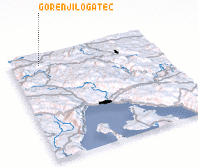 Places with similar names to Gorenji Logatec, Slovenia :: Disclaimer :: Information on this page comes without warranty of any kind |
||
|
Where is Gorenji Logatec? Elevation and coordinates ::
Latitude (lat): 45°54'28"N Longitude (lon): 14°11'56"E
Elevation (approx.): 492m (map arrows pan, magnifying glasses zoom) |
||
|
Visiting Gorenji Logatec? Hotel/Accommodation ::
Book a hotel in Gorenji Logatec Travel Guide ::
Buy a travel guide for Slovenia rental cars ::
car rental offers GPS waypoint ::
download a GPX waypoint (PoI) of Gorenji Logatec for your GPS receiver
|
||