|
search place name
|
||
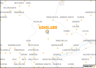
Do Holuba (Slovakia)Do Holuba is a town in Slovakia. An overview map of the region around Do Holuba is displayed below.
regional and 3d topo map of Do Holuba, Slovakia ::
Do Holuba airports ::
The nearest airport is SLD - Sliac, located 30.9 km east of Do Holuba.
Other airports nearby include PZY - Piestany (65.5 km west), BTS - Bratislava M R Stefanik (121.9 km south west), TAT - Poprad Tatry (122.9 km north east), OSR - Ostrava Mosnov (127.9 km north), Nearby towns ::
Prochot (1.9km south) //
Píla Kľak (4.4km north west) //
Nová Lehota (5.7km north) //
Horná Ždáňa (6.1km south east) //
Horná Trnávka (5.2km south east) //
Prestavlky (5.2km south east) //
Trubín (4.9km east) //
Smelákovci (7.5km south) //
Ostrý Grúň (6.7km south west) //
Kľak (6.1km south west) //
Janova Lehota (7.4km north east) //
Dolná Ždaňa (8.3km south east) //
Štefankov (8.3km south west) //
Hliník nad Hronom (8.9km south east) //
[all distances 'as the bird flies' and approximate] 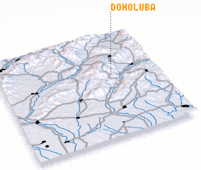 Places with similar names to Do Holuba, Slovakia :: Disclaimer :: Information on this page comes without warranty of any kind |
||
|
Where is Do Holuba? Elevation and coordinates ::
Latitude (lat): 48°37'0"N Longitude (lon): 18°43'0"E
Elevation (approx.): 639m (map arrows pan, magnifying glasses zoom) |
||
|
Visiting Do Holuba? Hotel/Accommodation ::
Book a hotel in Do Holuba Travel Guide ::
Buy a travel guide for Slovakia rental cars ::
car rental offers GPS waypoint ::
download a GPX waypoint (PoI) of Do Holuba for your GPS receiver
|
||