|
search place name
|
||
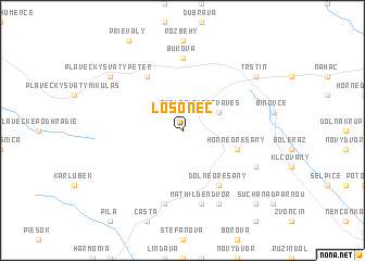
Lošonec (Slovakia)Lošonec is a town in Slovakia. An overview map of the region around Lošonec is displayed below.
regional and 3d topo map of Lošonec, Slovakia ::
Lošonec airports ::
The nearest airport is PZY - Piestany, located 35.3 km north east of Lošonec.
Other airports nearby include BTS - Bratislava M R Stefanik (37.5 km south), VIE - Vienna Schwechat (74.3 km south west), BRQ - Turany (90.6 km north west), PRV - Prerov (104.8 km north), Nearby towns ::
Smolenická Nová Ves (2.2km north east) //
Smolenice (3.1km north east) //
Horné Orešany (4.1km south east) //
Dolné Orešany (6.1km south east) //
Brezina (6.1km north west) //
Buková (7.4km north) //
Doľany (7.5km south) //
Mathilden Dvor (7.5km south) //
Dlhá (7.8km south) //
Blanka (6.2km south east) //
Plavecký Svätý Peter (7.4km north west) //
Trstín (7.4km north east) //
Rosuchov (7.4km north east) //
Košolná (8.9km south east) //
[all distances 'as the bird flies' and approximate]  Places with similar names to Lošonec, Slovakia ::
Disclaimer :: Information on this page comes without warranty of any kind |
||
|
Where is Lošonec? Elevation and coordinates ::
Latitude (lat): 48°29'0"N Longitude (lon): 17°24'0"E
Elevation (approx.): 247m (map arrows pan, magnifying glasses zoom) |
||
|
Visiting Lošonec? Hotel/Accommodation ::
Book a hotel in Lošonec Travel Guide ::
Buy a travel guide for Slovakia rental cars ::
car rental offers GPS waypoint ::
download a GPX waypoint (PoI) of Lošonec for your GPS receiver
|
||