|
search place name
|
||
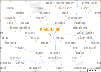
Majcichov (Slovakia)Majcichov is a town in Slovakia. An overview map of the region around Majcichov is displayed below.
regional and 3d topo map of Majcichov, Slovakia ::
Majcichov airports ::
The nearest airport is BTS - Bratislava M R Stefanik, located 33.7 km west of Majcichov.
Other airports nearby include PZY - Piestany (40.7 km north), VIE - Vienna Schwechat (81.4 km west), SLD - Sliac (117.8 km east), BRQ - Turany (118.7 km north west), Nearby towns ::
Hoste (1.9km south) //
Opoj (2.2km north east) //
Abrahám (3.9km south) //
Malý Háj (3.1km south east) //
Vlčkovce (4.5km north east) //
Pavlice (4.1km south west) //
Zeleneč (6.1km north west) //
Krížovany nad Dudváhom (6.1km north east) //
Jóži (4.9km west) //
Voderady (4.9km west) //
Malá Mača (7.5km south) //
Modranka (7.5km north) //
Újhely (7.8km south) //
Veľká Mača (6.2km south east) //
Pusté Úľany (7.4km south west) //
Zavar (8.3km north east) //
Hrnčiarovce nad Parnou (8.9km north west) //
[all distances 'as the bird flies' and approximate] 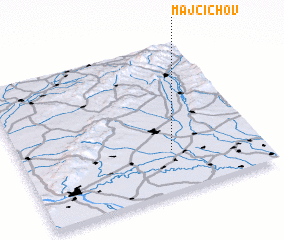 Places with similar names to Majcichov, Slovakia :: Disclaimer :: Information on this page comes without warranty of any kind |
||
|
Where is Majcichov? Elevation and coordinates ::
Latitude (lat): 48°17'0"N Longitude (lon): 17°38'0"E
Elevation (approx.): 126m (map arrows pan, magnifying glasses zoom) |
||
|
Visiting Majcichov? Hotel/Accommodation ::
Book a hotel in Majcichov Travel Guide ::
Buy a travel guide for Slovakia rental cars ::
car rental offers GPS waypoint ::
download a GPX waypoint (PoI) of Majcichov for your GPS receiver
|
||