|
search place name
|
||
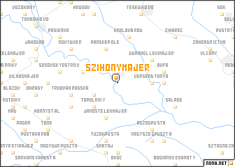
Szihony Majer (Slovakia)Szihony Majer is a town in Slovakia. An overview map of the region around Szihony Majer is displayed below.
regional and 3d topo map of Szihony Majer, Slovakia ::
Szihony Majer airports ::
The nearest airport is BTS - Bratislava M R Stefanik, located 48.8 km north west of Szihony Majer.
Other airports nearby include PZY - Piestany (69.5 km north), VIE - Vienna Schwechat (93.8 km west), SLD - Sliac (120.7 km north east), BUD - Budapest Ferihegy (124.8 km south east), Nearby towns ::
Trstice (1.9km north) //
Na Ostrove (3.1km south west) //
Topoľníky (4.5km south west) //
Versendtanya (3.7km east) //
Panské Pole (5.7km north) //
Jánostelek Majer (5.7km south) //
Horné Mýto (4.2km north west) //
Dunamelleki Majer (5.3km north east) //
Batoňa (5.0km east) //
Bufa (5.3km east) //
Kráľov Brod (7.5km north) //
Trhová Hradská (5.3km west) //
Čanádsky Dvor (6.2km south west) //
Nový Dvor (7.4km north west) //
Aszód Pusta (8.3km south east) //
[all distances 'as the bird flies' and approximate] 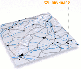 Places with similar names to Szihony Majer, Slovakia :: Disclaimer :: Information on this page comes without warranty of any kind |
||
|
Where is Szihony Majer? Elevation and coordinates ::
Latitude (lat): 48°0'0"N Longitude (lon): 17°49'0"E
Elevation (approx.): 110m (map arrows pan, magnifying glasses zoom) |
||
|
Visiting Szihony Majer? Hotel/Accommodation ::
Book a hotel in Szihony Majer Travel Guide ::
Buy a travel guide for Slovakia rental cars ::
car rental offers GPS waypoint ::
download a GPX waypoint (PoI) of Szihony Majer for your GPS receiver
|
||