|
search place name
|
||
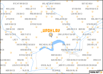
Upohlav (Slovakia)Upohlav is a town in Slovakia. An overview map of the region around Upohlav is displayed below.
regional and 3d topo map of Upohlav, Slovakia ::
Upohlav airports ::
The nearest airport is OSR - Ostrava Mosnov, located 62.1 km north of Upohlav.
Other airports nearby include PZY - Piestany (72.7 km south west), PRV - Prerov (76.8 km west), SLD - Sliac (80.5 km south east), BRQ - Turany (123.2 km west), Nearby towns ::
Hatné (1.9km north) //
Prosné (1.9km north) //
Malá Udiča (1.2km east) //
Dolné Podvažie (1.2km east) //
Veľká Udiča (1.2km east) //
Okrut (1.9km south) //
Jarky (3.7km south) //
Milochov (3.7km south) //
Klieština (3.1km north west) //
Nosice (3.9km south) //
Pecho v Laze (3.9km south) //
Nimnica (4.4km south west) //
Zaklepský Dvor (3.6km east) //
Hoštiná (3.6km west) //
Stupné (5.2km north east) //
Strážisko (5.2km north west) //
Podjaškov (6.1km north east) //
Orlové (5.2km south east) //
Púchov (5.2km south west) //
Pupeovci (7.4km north) //
Besné (7.5km north) //
Jasenica (5.2km east) //
Markovec (7.5km south) //
Orlovský Dvor (6.6km south east) //
Brvnište (6.6km north east) //
Papradno (7.8km north) //
Kunovec (7.8km south) //
Handersik (8.3km north west) //
Pagaňovce (8.3km north west) //
[all distances 'as the bird flies' and approximate] 
Disclaimer :: Information on this page comes without warranty of any kind |
||
|
Where is Upohlav? Elevation and coordinates ::
Latitude (lat): 49°10'0"N Longitude (lon): 18°23'0"E
Elevation (approx.): 461m (map arrows pan, magnifying glasses zoom) |
||
|
Visiting Upohlav? Hotel/Accommodation ::
Book a hotel in Upohlav Travel Guide ::
Buy a travel guide for Slovakia rental cars ::
car rental offers GPS waypoint ::
download a GPX waypoint (PoI) of Upohlav for your GPS receiver
|
||