|
search place name
|
||
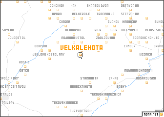
Veľká Lehota (Slovakia)Veľká Lehota is a town in Slovakia. An overview map of the region around Veľká Lehota is displayed below.
regional and 3d topo map of Veľká Lehota, Slovakia ::
Veľká Lehota airports ::
The nearest airport is SLD - Sliac, located 46.0 km north east of Veľká Lehota.
Other airports nearby include PZY - Piestany (57.3 km west), BTS - Bratislava M R Stefanik (105.7 km west), BUD - Budapest Ferihegy (125.5 km south east), PRV - Prerov (136.5 km north west), Nearby towns ::
Šajbov (1.9km north) //
Malá Lehota (3.7km north) //
Blažkov (3.7km north) //
Hubáčov (3.1km north east) //
Rajnohov Štál (3.9km north) //
Stará Huta (5.7km south) //
Bukovina (5.7km south) //
Debnárov (5.7km north) //
Brezovo (5.2km north west) //
Zdolžavina (5.2km north east) //
Píla (6.1km north east) //
Nemecká Huta (7.4km south) //
Jedľové Kostoľany (4.9km west) //
Lukačov Štál (5.3km west) //
Abraham (6.7km north east) //
Cieger (7.8km north) //
Záhrb (7.4km south east) //
Šula (7.4km north east) //
Pišovci (8.3km north east) //
Župkov (8.9km north east) //
[all distances 'as the bird flies' and approximate] 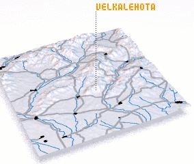 Places with similar names to Veľká Lehota, Slovakia ::
// Velká Lhota (CZ)
// Veľká Lehota (SK)
// Velká Lhota (CZ)
// Velká Lhota (CZ)
// Velká Lhota (CZ)
Disclaimer :: Information on this page comes without warranty of any kind |
||
|
Where is Veľká Lehota? Elevation and coordinates ::
Latitude (lat): 48°28'0"N Longitude (lon): 18°34'0"E
Elevation (approx.): 603m (map arrows pan, magnifying glasses zoom) |
||
|
Visiting Veľká Lehota? Hotel/Accommodation ::
Book a hotel in Veľká Lehota Travel Guide ::
Buy a travel guide for Slovakia rental cars ::
car rental offers GPS waypoint ::
download a GPX waypoint (PoI) of Veľká Lehota for your GPS receiver
|
||