|
search place name
|
||
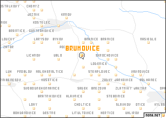
Brumovice (Czech Republic)Brumovice is a town in Czech Republic. An overview map of the region around Brumovice is displayed below.
regional and 3d topo map of Brumovice, Czech Republic ::
Brumovice airports ::
The nearest airport is OSR - Ostrava Mosnov, located 44.1 km south east of Brumovice.
Other airports nearby include PRV - Prerov (70.3 km south), KTW - Katowice Pyrzowice (107.7 km north east), BRQ - Turany (122.8 km south west), WRO - Wroclaw Strachowice (135.4 km north west), Nearby towns ::
Tábor (1.9km south) //
Úvalno (3.7km north) //
Pocheň (3.0km north west) //
Branice (3.9km north) //
Loděnice (3.0km south east) //
Velké Heraltice (3.9km south) //
Kamenec (3.9km south) //
Stemplovec (4.4km south east) //
Kolná (3.6km west) //
Skrochovice (3.6km east) //
Úblo (3.6km west) //
Boboluszki (4.0km north east) //
Branice (5.1km north east) //
Býkov (5.1km north west) //
Jamnice (6.0km south east) //
Wysoka (4.8km east) //
Sádek (7.4km south) //
Holasovice (5.1km east) //
Zadky (6.6km south east) //
Březová (7.8km south) //
Neplachovice (6.0km south east) //
Malé Heraltice (6.0km south west) //
Chařová (8.2km north west) //
Košetice (7.3km south west) //
[all distances 'as the bird flies' and approximate]  Places with similar names to Brumovice, Czech Republic ::
// Brumovice (CZ)
// Broumovice (CZ)
Disclaimer :: Information on this page comes without warranty of any kind |
||
|
Where is Brumovice? Elevation and coordinates ::
Latitude (lat): 50°1'0"N Longitude (lon): 17°45'0"E
Elevation (approx.): 329m (map arrows pan, magnifying glasses zoom) |
||
|
Visiting Brumovice? Hotel/Accommodation ::
Book a hotel in Brumovice Travel Guide ::
rental cars ::
car rental offers GPS waypoint ::
download a GPX waypoint (PoI) of Brumovice for your GPS receiver
|
||