|
search place name
|
||
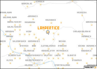
Lampertice (Czech Republic)Lampertice is a town in Czech Republic. An overview map of the region around Lampertice is displayed below.
regional and 3d topo map of Lampertice, Czech Republic ::
Lampertice airports ::
The nearest airport is PED - Pardubice, located 74.2 km south of Lampertice.
Other airports nearby include WRO - Wroclaw Strachowice (81.8 km north east), BBJ - Bautzen (116.4 km north west), PRG - Prague Ruzyne (135.7 km south west), IEG - Zielona Gora Babimost (164.1 km north), Nearby towns ::
Královec (1.4km north east) //
Černá Voda (2.2km north west) //
Křenov (2.2km south west) //
Bernartice (2.2km south east) //
Vrchová (2.3km east) //
Prkenný Dŭl (3.0km south west) //
Miszkowice (4.6km north) //
Žacléř (3.3km west) //
Zlatá Olešnice (5.6km south) //
Bobr (3.5km west) //
Vernířovice (5.1km south west) //
Bečkov (5.1km south east) //
Lubawka (5.5km north east) //
Vizov (4.7km west) //
Nové Voletiny (7.4km south) //
Libeč (7.5km south) //
Babí (6.6km south west) //
Rybníček (6.6km south east) //
Niedamirów (5.8km north west) //
Debrné (7.8km south) //
Jarkowice (7.1km north west) //
Petříkovice (8.2km south east) //
Kalná Voda (8.8km south west) //
[all distances 'as the bird flies' and approximate]  Places with similar names to Lampertice, Czech Republic :: Disclaimer :: Information on this page comes without warranty of any kind |
||
|
Where is Lampertice? Elevation and coordinates ::
Latitude (lat): 50°40'0"N Longitude (lon): 15°57'0"E
Elevation (approx.): 528m (map arrows pan, magnifying glasses zoom) |
||
|
Visiting Lampertice? Hotel/Accommodation ::
Book a hotel in Lampertice Travel Guide ::
rental cars ::
car rental offers GPS waypoint ::
download a GPX waypoint (PoI) of Lampertice for your GPS receiver
|
||