|
search place name
|
||
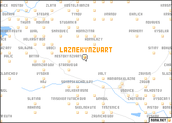
Lázně Kynžvart (Czech Republic)Lázně Kynžvart is a town in Czech Republic. An overview map of the region around Lázně Kynžvart is displayed below.
regional and 3d topo map of Lázně Kynžvart, Czech Republic ::
Lázně Kynžvart airports ::
The nearest airport is KLV - Karlovy Vary, located 28.9 km north east of Lázně Kynžvart.
Other airports nearby include HOQ - Hof Plauen (63.3 km north west), BYU - Bayreuth (71.4 km west), AOC - Altenburg Nobitz (107.7 km north), PRG - Prague Ruzyne (116.9 km east), Nearby towns ::
Město Kynžvart (2.4km west) //
Horní Lazy (3.9km north) //
Stará Voda (3.0km south west) //
Valy (4.4km south east) //
Horní Žitná (5.6km north) //
Dolní Žitná (5.7km north) //
Sekerské Chalupy (5.7km south) //
Dolní Lazy (5.7km north) //
Jedlová (6.0km south west) //
Velká Hleďsebe (6.0km south east) //
Klimentov (6.0km south east) //
Ostrov (7.5km north) //
Úbočí (5.1km west) //
Velké Krásné (7.5km south) //
Malé Krásné (7.5km south) //
Malá Hleďsebe (7.5km south) //
Smrkovec (6.6km north west) //
Podlesí (6.0km north west) //
Studánka (7.8km north) //
Hörgassing (7.3km south east) //
Mariánské Lázně (7.1km south east) //
[all distances 'as the bird flies' and approximate]  Places with similar names to Lázně Kynžvart, Czech Republic :: Disclaimer :: Information on this page comes without warranty of any kind |
||
|
Where is Lázně Kynžvart? Elevation and coordinates ::
Latitude (lat): 50°1'0"N Longitude (lon): 12°38'0"E
Elevation (approx.): 862m (map arrows pan, magnifying glasses zoom) |
||
|
Visiting Lázně Kynžvart? Hotel/Accommodation ::
Book a hotel in Lázně Kynžvart Travel Guide ::
rental cars ::
car rental offers GPS waypoint ::
download a GPX waypoint (PoI) of Lázně Kynžvart for your GPS receiver
|
||