|
search place name
|
||
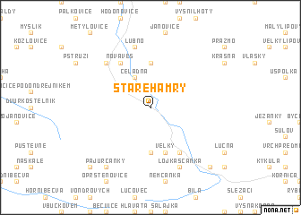
Staré Hamry (Czech Republic)Staré Hamry is a town in Czech Republic. An overview map of the region around Staré Hamry is displayed below.
regional and 3d topo map of Staré Hamry, Czech Republic ::
Staré Hamry airports ::
The nearest airport is OSR - Ostrava Mosnov, located 27.7 km north west of Staré Hamry.
Other airports nearby include PRV - Prerov (73.1 km west), PZY - Piestany (109.3 km south west), SLD - Sliac (113.1 km south east), KTW - Katowice Pyrzowice (115.5 km north east), Nearby towns ::
Ostravice (2.2km north west) //
Čeladná (3.9km north) //
Malenovice (5.6km north) //
Břestový (5.6km south) //
Velký (5.7km south) //
Nová Ves (6.1km north west) //
Jamník (6.1km south east) //
Lubno (7.5km north) //
Frýdlant nad Ostravicí (6.6km north west) //
Lojkaščanka (7.8km south) //
Pajurcanky (8.2km south west) //
Mohyla (8.8km south west) //
Gachovky (8.8km south east) //
[all distances 'as the bird flies' and approximate] 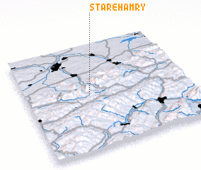 Places with similar names to Staré Hamry, Czech Republic ::
Disclaimer :: Information on this page comes without warranty of any kind |
||
|
Where is Staré Hamry? Elevation and coordinates ::
Latitude (lat): 49°32'0"N Longitude (lon): 18°24'0"E
Elevation (approx.): 469m (map arrows pan, magnifying glasses zoom) |
||
|
Visiting Staré Hamry? Hotel/Accommodation ::
Book a hotel in Staré Hamry Travel Guide ::
rental cars ::
car rental offers GPS waypoint ::
download a GPX waypoint (PoI) of Staré Hamry for your GPS receiver
|
||