|
search place name
|
||
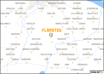
Flamsted (Nordjylland, Denmark)Flamsted is a town in the Nordjylland region of Denmark. An overview map of the region around Flamsted is displayed below.
regional and 3d topo map of Flamsted, Denmark ::
Flamsted airports ::
The nearest airport is AAL - Aalborg, located 20.9 km north of Flamsted.
Other airports nearby include TED - Thisted (78.5 km west), AAR - Aarhus (79.5 km south east), KRP - Karup (86.2 km south west), BLL - Billund (140.3 km south), Nearby towns ::
Gerding (1.9km south) //
Horsens (2.7km south east) //
Oppelstrup (4.2km north east) //
Håls (3.0km east) //
Volsted (3.6km south west) //
Askildrup (5.9km south) //
Skindbjerg (4.8km south west) //
Nøvling (7.4km north) //
Fjellerad (4.4km north east) //
Mjels (4.4km north west) //
Nøtten (4.4km north west) //
Fræer (7.5km south) //
Sejlstrup (7.5km south) //
Lundby (6.3km north east) //
Gunderup (5.5km north east) //
Dollerup (5.5km south east) //
Blenstrup (5.5km south east) //
Ferslev (5.5km north west) //
Skovstrup (6.9km north east) //
Gammel Skørping (6.9km south west) //
Store Brøndum (8.0km south) //
Mølholm (8.0km south) //
[all distances 'as the bird flies' and approximate]  Places with similar names to Flamsted, Denmark ::
Disclaimer :: Information on this page comes without warranty of any kind |
||
|
Where is Flamsted? Elevation and coordinates ::
Latitude (lat): 56°55'0"N Longitude (lon): 9°58'0"E
Elevation (approx.): 42m (map arrows pan, magnifying glasses zoom) |
||
|
Visiting Flamsted? Hotel/Accommodation ::
Book a hotel in Flamsted Travel Guide ::
Buy a travel guide for Denmark rental cars ::
car rental offers GPS waypoint ::
download a GPX waypoint (PoI) of Flamsted for your GPS receiver
|
||