|
search place name
|
||
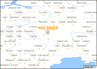
Hvilsager (Århus, Denmark)Hvilsager is a town in the Århus region of Denmark. An overview map of the region around Hvilsager is displayed below.
regional and 3d topo map of Hvilsager, Denmark ::
Hvilsager airports ::
The nearest airport is AAR - Aarhus, located 18.2 km south east of Hvilsager.
Other airports nearby include KRP - Karup (76.2 km west), AAL - Aalborg (86.5 km north), ODE - Odense (99.1 km south), BLL - Billund (102.2 km south west), Nearby towns ::
Bøjen (1.9km north) //
Bendstrup (1.0km west) //
Termestrup (1.9km south) //
Kastrup (2.1km north east) //
Hejlskov (2.1km north west) //
Ring (3.8km north) //
Oustrup (3.8km north) //
Mørke (4.2km south east) //
Andi (3.1km west) //
Syvveje (3.6km north west) //
Karlby (3.6km south west) //
Hornslet (5.7km south) //
Øster Alling (5.9km north) //
Ringsø (4.8km north east) //
Tendrup (5.9km south) //
Bale (5.9km south) //
Ommestrup (4.8km south east) //
Skørring (4.1km west) //
Eskerod (7.4km south) //
Liltved (7.5km north) //
Rodskov (7.5km south) //
Auning (7.7km north) //
Falkærgårde (5.5km south east) //
Vester Alling (6.9km north west) //
Ugelbølle (6.9km south east) //
Krajbjerg (8.5km south west) //
[all distances 'as the bird flies' and approximate] 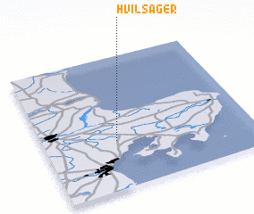 Places with similar names to Hvilsager, Denmark ::
// Valsigiara (IT)
Disclaimer :: Information on this page comes without warranty of any kind |
||
|
Where is Hvilsager? Elevation and coordinates ::
Latitude (lat): 56°22'0"N Longitude (lon): 10°21'0"E
Elevation (approx.): 47m (map arrows pan, magnifying glasses zoom) |
||
|
Visiting Hvilsager? Hotel/Accommodation ::
Book a hotel in Hvilsager Travel Guide ::
Buy a travel guide for Denmark rental cars ::
car rental offers GPS waypoint ::
download a GPX waypoint (PoI) of Hvilsager for your GPS receiver
|
||