|
search place name
|
||
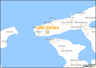
Karlsminde (Frederiksborg, Denmark)Karlsminde is a town in the Frederiksborg region of Denmark. An overview map of the region around Karlsminde is displayed below.
regional and 3d topo map of Karlsminde, Denmark ::
nearby GPS traces from timatio ::
Karlsminde airports ::
The nearest airport is RKE - Copenhagen Roskilde, located 43.1 km south of Karlsminde.
Other airports nearby include CPH - Copenhagen Kastrup (60.1 km south east), JLD - Landskrona (60.6 km east), AAR - Aarhus (88.7 km north west), HAD - Halmstad (100.3 km north east), Nearby towns ::
Sølager (0.0km north) //
Ullerup (1.9km north) //
Torpmagle (2.1km north east) //
Kulhuse (2.9km south) //
Nødebo (3.7km north) //
Lynæs (2.1km west) //
Tømmerup (3.8km north) //
Kikhavn (3.8km north) //
Hundested (2.8km north west) //
Hornsved (3.8km south) //
Bakkegårde (3.8km south) //
Sverkilstrup (3.6km north east) //
Hald (5.7km north) //
Torup (4.8km north east) //
Skoven (6.4km south east) //
Hågendrup (5.6km north east) //
Tollerup (6.9km north east) //
Seksgårde (8.5km south east) //
[all distances 'as the bird flies' and approximate] 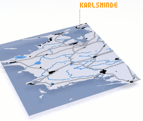 Places with similar names to Karlsminde, Denmark :: Disclaimer :: Information on this page comes without warranty of any kind |
||
|
Where is Karlsminde? Elevation and coordinates ::
Latitude (lat): 55°57'0"N Longitude (lon): 11°54'0"E
Elevation (approx.): 15m (map arrows pan, magnifying glasses zoom) |
||
|
Visiting Karlsminde? Hotel/Accommodation ::
Book a hotel in Karlsminde Travel Guide ::
Buy a travel guide for Denmark rental cars ::
car rental offers GPS waypoint ::
download a GPX waypoint (PoI) of Karlsminde for your GPS receiver
|
||