|
search place name
|
||
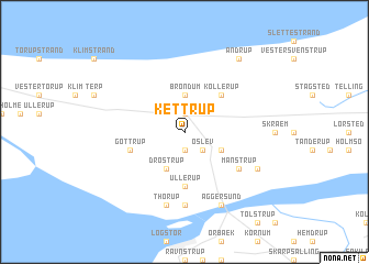
Kettrup (Viborg, Denmark)Kettrup is a town in the Viborg region of Denmark. An overview map of the region around Kettrup is displayed below.
regional and 3d topo map of Kettrup, Denmark ::
Kettrup airports ::
The nearest airport is TED - Thisted, located 34.1 km west of Kettrup.
Other airports nearby include AAL - Aalborg (35.4 km east), KRP - Karup (86.1 km south), AAR - Aarhus (119.0 km south east), STA - Stauning (132.4 km south west), Nearby towns ::
Fjerritslev (1.9km north) //
Korsholm (1.9km south) //
Øslev (2.1km south east) //
Brøndum (3.7km north) //
Husby (2.7km south east) //
Drøstrup (3.8km south) //
Kollerup (4.2km north east) //
Ullerup (5.6km south) //
Gøttrup (3.5km south west) //
Manstrup (4.8km south east) //
Aggersborg (7.4km south) //
Thorup (7.5km south) //
Bejstrup (5.5km south east) //
Aggersund (7.7km south) //
Andrup (8.0km north) //
[all distances 'as the bird flies' and approximate] 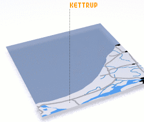 Places with similar names to Kettrup, Denmark ::
Disclaimer :: Information on this page comes without warranty of any kind |
||
|
Where is Kettrup? Elevation and coordinates ::
Latitude (lat): 57°4'0"N Longitude (lon): 9°16'0"E
Elevation (approx.): 26m (map arrows pan, magnifying glasses zoom) |
||
|
Visiting Kettrup? Hotel/Accommodation ::
Book a hotel in Kettrup Travel Guide ::
Buy a travel guide for Denmark rental cars ::
car rental offers GPS waypoint ::
download a GPX waypoint (PoI) of Kettrup for your GPS receiver
|
||