|
search place name
|
||
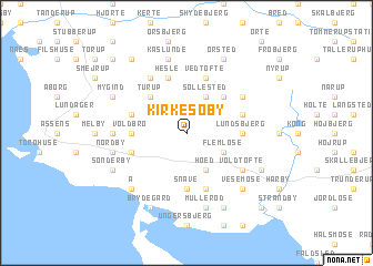
Kirke-Søby (Fyn, Denmark)Kirke-Søby is a town in the Fyn region of Denmark. An overview map of the region around Kirke-Søby is displayed below.
regional and 3d topo map of Kirke-Søby, Denmark ::
Kirke-Søby airports ::
The nearest airport is ODE - Odense, located 30.0 km north east of Kirke-Søby.
Other airports nearby include SGD - Soenderborg Sonderborg (37.0 km south west), SKS - Skrydstrup (49.1 km west), BLL - Billund (76.7 km north west), EBJ - Esbjerg (98.1 km west), Nearby towns ::
Vistorp (1.9km north) //
Sø Søby (2.1km north west) //
Søllested (3.9km north) //
Flemløse (2.8km south east) //
Høed (3.9km south) //
Turup (4.3km north west) //
Egemosedam (4.3km north east) //
Lundsbjerg (3.2km east) //
Egerup (3.2km west) //
Voldbro (3.2km west) //
Snave (5.6km south) //
Hesle (5.7km north) //
Mellemballe (5.7km north) //
Dærup (3.7km north east) //
Gamtofte (3.7km north west) //
Vedtofte (5.7km north) //
Ebberup (3.7km south west) //
Skårup (5.7km south) //
Dreslette (5.7km south) //
Bukkerup (4.9km north east) //
Blangstrup (5.9km north) //
Voldtofte (4.9km south east) //
Kærum (4.2km west) //
Kaslunde (7.5km north) //
Nordby (4.6km south west) //
Mullerød (7.5km south) //
Vesemose (6.4km south east) //
Strærup (6.4km south east) //
Å (6.4km south west) //
[all distances 'as the bird flies' and approximate]  Places with similar names to Kirke-Søby, Denmark ::
// Grigsby (US)
// Grigsby (US)
// Grigsby (US)
// Karkas Āb (IR)
// Qareh Qaşşāb (IR)
// Kroksbo (SE)
// Kirke Såby (DK)
// Grycksbo (SE)
// Krogsby (FI)
// Croxby (GB)
Disclaimer :: Information on this page comes without warranty of any kind |
||
|
Where is Kirke-Søby? Elevation and coordinates ::
Latitude (lat): 55°16'0"N Longitude (lon): 10°2'0"E
Elevation (approx.): 59m (map arrows pan, magnifying glasses zoom) |
||
|
Visiting Kirke-Søby? Hotel/Accommodation ::
Book a hotel in Kirke-Søby Travel Guide ::
Buy a travel guide for Denmark rental cars ::
car rental offers GPS waypoint ::
download a GPX waypoint (PoI) of Kirke-Søby for your GPS receiver
|
||