|
search place name
|
||
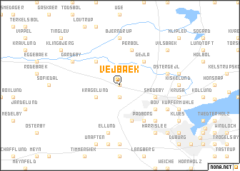
Vejbæk (Sønderjylland, Denmark)Vejbæk is a town in the Sønderjylland region of Denmark. An overview map of the region around Vejbæk is displayed below.
regional and 3d topo map of Vejbæk, Denmark ::
Vejbæk airports ::
The nearest airport is SGD - Soenderborg Sonderborg, located 31.3 km east of Vejbæk.
Other airports nearby include SKS - Skrydstrup (40.2 km north), GWT - Westerland Sylt (63.9 km west), KEL - Kiel Holtenau (75.4 km south east), EBJ - Esbjerg (88.6 km north west), Nearby towns ::
Frydendal (0.0km north) //
Fårhus (1.9km south) //
Kragelund (2.8km south west) //
Bajstrup (4.3km north west) //
Gejlå (4.3km north east) //
Perbøl (5.7km north) //
Smedeby (3.7km south east) //
Frøslev (5.7km south) //
Bov (4.9km south east) //
Padborg (6.0km south) //
Bjerndrup (7.4km north) //
Øster Gejl (4.7km north east) //
Ellund (7.5km south) //
Niehuus (6.4km south east) //
Broderup (5.7km north west) //
Gårdeby (5.7km north west) //
Karlsberg (5.7km south east) //
Vilsbæk (7.0km north east) //
Harrislee (8.1km south east) //
Muusbek (8.6km south east) //
Harrisleefeld (8.6km south east) //
[all distances 'as the bird flies' and approximate]  Places with similar names to Vejbæk, Denmark :: Disclaimer :: Information on this page comes without warranty of any kind |
||
|
Where is Vejbæk? Elevation and coordinates ::
Latitude (lat): 54°52'0"N Longitude (lon): 9°20'0"E
Elevation (approx.): 33m (map arrows pan, magnifying glasses zoom) |
||
|
Visiting Vejbæk? Hotel/Accommodation ::
Book a hotel in Vejbæk Travel Guide ::
Buy a travel guide for Denmark rental cars ::
car rental offers GPS waypoint ::
download a GPX waypoint (PoI) of Vejbæk for your GPS receiver
|
||