|
search place name
|
||
Boda (Kronoberg, Sweden)Boda is a town in the Kronoberg region of Sweden. An overview map of the region around Boda is displayed below.
regional and 3d topo map of Boda, Sweden ::
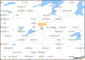
Boda airports ::
The nearest airport is HAD - Halmstad, located 48.8 km west of Boda.
Other airports nearby include VXO - Vaxjo Kronoberg (72.5 km east), KID - Kristianstad (91.4 km south), JLD - Landskrona (96.0 km south west), RNB - Ronneby (112.4 km south east), Nearby towns ::
Sunnertorpa (1.0km west) //
Stackarp (2.1km north west) //
Källshult (2.0km east) //
Ränte (2.0km west) //
Rya (2.0km west) //
Skäckarp (3.8km north) //
Äsphult (3.8km south) //
Torpa (2.8km north west) //
Forsa (2.8km south west) //
Mjäla (4.2km north west) //
Balkö (3.1km east) //
Hallarp (5.7km north) //
Staverhult (4.8km south east) //
Groeryd (5.9km south) //
Rönninge (4.5km south east) //
Ekön (6.3km south west) //
Bökhult (5.5km north east) //
Råaköp (5.5km south west) //
Kärr (6.9km south east) //
Viggåsa (8.0km north) //
Skeen (8.0km north) //
Tommaryd (8.5km south east) //
[all distances 'as the bird flies' and approximate] 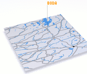 Places with similar names to Boda, Sweden ::
Disclaimer :: Information on this page comes without warranty of any kind |
||
|
Where is Boda? Elevation and coordinates ::
Latitude (lat): 56°42'0"N Longitude (lon): 13°37'0"E
Elevation (approx.): 161m (map arrows pan, magnifying glasses zoom) |
||
|
Visiting Boda? Hotel/Accommodation ::
Book a hotel in Boda Travel Guide ::
Buy a travel guide for Sweden rental cars ::
car rental offers GPS waypoint ::
download a GPX waypoint (PoI) of Boda for your GPS receiver
|
||