|
search place name
|
||
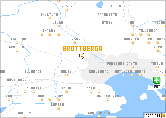
Brottberga (Västmanland, Sweden)Brottberga is a town in the Västmanland region of Sweden. An overview map of the region around Brottberga is displayed below.
regional and 3d topo map of Brottberga, Sweden ::
Brottberga airports ::
The nearest airport is VST - Vasteras, located 9.8 km south east of Brottberga.
Other airports nearby include ARN - Stockholm Arlanda (81.0 km east), BMA - Stockholm Bromma (88.3 km east), ORB - Orebro (93.9 km south west), NYO - Stockholm Skavsta (97.2 km south), Nearby towns ::
Skerike (2.1km north west) //
Rustberga (2.6km north west) //
Forsby (3.8km north) //
Bälby (4.2km south west) //
Karlsberg (4.2km south east) //
Gotö (7.5km south) //
Västerås (4.2km south east) //
Gocksta (6.2km north west) //
Fälvi (7.6km south) //
Ekbacken (7.6km south) //
Skålby (6.7km north west) //
Myrby (7.9km north) //
Frösvi (7.9km north) //
Lejde (7.9km north) //
[all distances 'as the bird flies' and approximate]  Places with similar names to Brottberga, Sweden ::
// Bartberg (AT)
// Breitberg (AT)
// Bredeberg (DE)
// Breiteberg (DE)
// Breiteberg (DE)
// Burdberg (DE)
// Broad Brook (US)
// Brattberg (SE)
// Birdbrook (GB)
// Breedbroek (BE)
Disclaimer :: Information on this page comes without warranty of any kind |
||
|
Where is Brottberga? Elevation and coordinates ::
Latitude (lat): 59°38'0"N Longitude (lon): 16°29'0"E
Elevation (approx.): 34m (map arrows pan, magnifying glasses zoom) |
||
|
Visiting Brottberga? Hotel/Accommodation ::
Book a hotel in Brottberga Travel Guide ::
Buy a travel guide for Sweden rental cars ::
car rental offers GPS waypoint ::
download a GPX waypoint (PoI) of Brottberga for your GPS receiver
|
||