|
search place name
|
||
Gärdslöv ((( Kristianstad )), Sweden)Gärdslöv is a town in the (( Kristianstad )) region of Sweden. An overview map of the region around Gärdslöv is displayed below.
regional and 3d topo map of Gärdslöv, Sweden ::
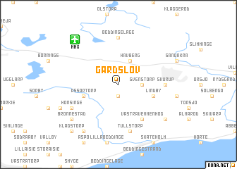
Gärdslöv airports ::
The nearest airport is MMX - Malmoe Sturup, located 8.1 km north west of Gärdslöv.
Other airports nearby include CPH - Copenhagen Kastrup (51.9 km west), JLD - Landskrona (63.9 km north west), KID - Kristianstad (65.2 km north east), RKE - Copenhagen Roskilde (83.3 km west), Nearby towns ::
Önnarp (1.9km south) //
Svenstorp (2.1km east) //
Havberg (3.9km north) //
Assartorp (3.7km south west) //
Lindby (3.7km south east) //
Västra Vemmenhög (5.9km south) //
Beddinge Läge (7.4km north) //
Skurup (4.2km east) //
Beddinge (7.5km south) //
Tullstorp (7.5km south) //
Hönsinge (5.6km south west) //
Brönnestad (7.0km south west) //
Jordberga (8.1km south west) //
Östra Vemmenhög (7.0km south east) //
Klagstorp (8.5km south west) //
[all distances 'as the bird flies' and approximate] 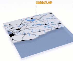 Places with similar names to Gärdslöv, Sweden :: Disclaimer :: Information on this page comes without warranty of any kind |
||
|
Where is Gärdslöv? Elevation and coordinates ::
Latitude (lat): 55°28'0"N Longitude (lon): 13°26'0"E
Elevation (approx.): 38m (map arrows pan, magnifying glasses zoom) |
||
|
Visiting Gärdslöv? Hotel/Accommodation ::
Book a hotel in Gärdslöv Travel Guide ::
Buy a travel guide for Sweden rental cars ::
car rental offers GPS waypoint ::
download a GPX waypoint (PoI) of Gärdslöv for your GPS receiver
|
||