|
search place name
|
||
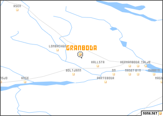
Granboda (Västernorrland, Sweden)Granboda is a town in the Västernorrland region of Sweden. An overview map of the region around Granboda is displayed below.
regional and 3d topo map of Granboda, Sweden ::
Granboda airports ::
The nearest airport is SDL - Sundsvall Harnosand, located 88.1 km east of Granboda.
Other airports nearby include EVG - Sveg (89.2 km south west), OSD - Ostersund Froson (93.9 km north west), HUV - Hudiksvall (113.4 km south east), MXX - Mora (190.5 km south), Nearby towns ::
 Places with similar names to Granboda, Sweden ::
// Karnobat (BG)
// Garin Beydou (NE)
// Guérin Abdou (NE)
// Gūrānābād (IR)
// Kūrānābād (IR)
// Qarnābād (IR)
// Koranbod (SO)
// Korunbod (SO)
// Granboda (FI)
// Granboda (FI)
Disclaimer :: Information on this page comes without warranty of any kind |
||
|
Where is Granboda? Elevation and coordinates ::
Latitude (lat): 62°34'0"N Longitude (lon): 15°44'0"E
(map arrows pan, magnifying glasses zoom) |
||
|
Visiting Granboda? Hotel/Accommodation ::
Book a hotel in Granboda Travel Guide ::
Buy a travel guide for Sweden rental cars ::
car rental offers GPS waypoint ::
download a GPX waypoint (PoI) of Granboda for your GPS receiver
|
||