|
search place name
|
||
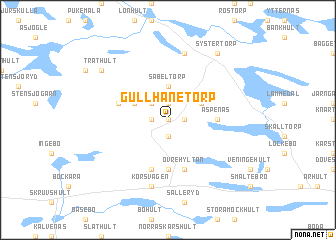
Gullhanetorp (Kalmar, Sweden)Gullhanetorp is a town in the Kalmar region of Sweden. An overview map of the region around Gullhanetorp is displayed below.
regional and 3d topo map of Gullhanetorp, Sweden ::
Gullhanetorp airports ::
The nearest airport is OSK - Oskarshamn, located 20.0 km east of Gullhanetorp.
Other airports nearby include HLF - Hultsfred (29.7 km north west), KLR - Kalkmar Kalmar (72.5 km south), VXO - Vaxjo Kronoberg (98.1 km south west), LPI - Linkoeping Saab (122.9 km north), Nearby towns ::
Östantorp (0.0km north) //
Applekulla (0.0km north) //
Bråbo (0.0km north) //
Libbershult (1.9km south) //
Brånäs (1.0km east) //
Stora Bråbo (1.0km west) //
Bjälebo (1.0km west) //
Saxtorp (1.9km north) //
Lilla Bråbo (2.1km north west) //
Bråhult (2.1km north west) //
Sabeltorp (3.7km north) //
Eversnäs (2.7km north east) //
Källeryd (2.7km north west) //
Nedre Hyltan (5.6km south) //
Äspenäs (3.0km east) //
Övre Hyltan (5.6km south) //
Gransmåla (5.6km south) //
Fallebo (3.5km north west) //
Korsvägen (7.5km south) //
Färgshult (7.5km south) //
Kristdala (7.5km north) //
Träthult (6.8km north west) //
Malghult (8.0km north) //
Systertorp (8.0km north) //
[all distances 'as the bird flies' and approximate]  Places with similar names to Gullhanetorp, Sweden :: Disclaimer :: Information on this page comes without warranty of any kind |
||
|
Where is Gullhanetorp? Elevation and coordinates ::
Latitude (lat): 57°20'0"N Longitude (lon): 16°10'0"E
Elevation (approx.): 86m (map arrows pan, magnifying glasses zoom) |
||
|
Visiting Gullhanetorp? Hotel/Accommodation ::
Book a hotel in Gullhanetorp Travel Guide ::
Buy a travel guide for Sweden rental cars ::
car rental offers GPS waypoint ::
download a GPX waypoint (PoI) of Gullhanetorp for your GPS receiver
|
||