|
search place name
|
||
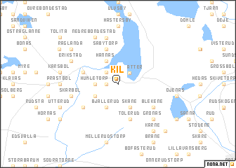
Kil (Värmland, Sweden)Kil is a town in the Värmland region of Sweden. An overview map of the region around Kil is displayed below.
regional and 3d topo map of Kil, Sweden ::
Kil airports ::
The nearest airport is KSK - Karlskoga, located 69.6 km east of Kil.
Other airports nearby include ORB - Orebro (103.2 km east), LDK - Lidkoping (117.4 km south), KVB - Skovde (124.0 km south), THN - Trollhattan Vanersborg (144.8 km south west), Nearby towns ::
Fryksta (1.9km north) //
Jonsbol (0.9km west) //
Runnevål (0.9km west) //
Välsätter (2.0km north east) //
Tollestad (2.1km north west) //
Humletorp (1.9km west) //
Hannäs (3.8km north) //
Skåne (3.8km south) //
Lersäter (2.6km south west) //
Bjällerud (3.8km south) //
Gunnita (3.4km north west) //
Tolerud (5.6km south) //
Säbytorp (5.6km north) //
Blekene (4.7km south east) //
Smedstad (4.7km south west) //
Annita (7.4km north) //
Skårbol (4.2km south west) //
Grönäs (6.2km south east) //
Erikstad (5.3km north west) //
Nedre Bondestad (7.6km north) //
Kärne (7.9km south) //
Råglanda (6.7km north west) //
Våle (8.3km south east) //
[all distances 'as the bird flies' and approximate] 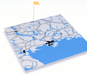 Places with similar names to Kil, Sweden ::
Disclaimer :: Information on this page comes without warranty of any kind |
||
|
Where is Kil? Elevation and coordinates ::
Latitude (lat): 59°31'0"N Longitude (lon): 13°19'0"E
Elevation (approx.): 102m (map arrows pan, magnifying glasses zoom) |
||
|
Visiting Kil? Hotel/Accommodation ::
Book a hotel in Kil Travel Guide ::
Buy a travel guide for Sweden rental cars ::
car rental offers GPS waypoint ::
download a GPX waypoint (PoI) of Kil for your GPS receiver
|
||