|
search place name
|
||
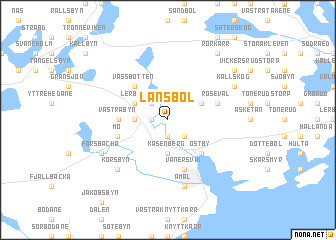
Lånsbol ((( Älvsborg )), Sweden)Lånsbol is a town in the (( Älvsborg )) region of Sweden. An overview map of the region around Lånsbol is displayed below.
regional and 3d topo map of Lånsbol, Sweden ::
Lånsbol airports ::
The nearest airport is LDK - Lidkoping, located 77.9 km south of Lånsbol.
Other airports nearby include THN - Trollhattan Vanersborg (91.1 km south), KVB - Skovde (104.7 km south east), KSK - Karlskoga (106.6 km east), OSL - Oslo Gardermoen (149.6 km north west), Nearby towns ::
Packebyn (1.0km west) //
Segersbyn (1.9km south) //
Låbytorp (2.1km north west) //
Stora Berga (2.1km south east) //
Gärdsbyn (2.1km south east) //
Hennebyn (1.9km west) //
Kasenberg (3.7km south) //
Lerbyn (2.7km north west) //
Århult (2.7km north east) //
Vassbotten (4.2km north west) //
Låbyn (4.2km north west) //
Gressbol (4.2km north west) //
Östby (4.2km south east) //
Östra Byn (2.9km west) //
Persbyn (2.9km west) //
Västra Byn (2.9km west) //
Rösevål (3.4km north east) //
Vänersvik (5.6km south) //
Mo (3.4km south west) //
Åmål (7.5km south) //
Korsbyn (6.3km south west) //
Forsbacka (5.3km south west) //
Kallskog (5.3km north east) //
Rörkärr (7.9km north) //
Vickersrud (6.7km north east) //
[all distances 'as the bird flies' and approximate]  Places with similar names to Lånsbol, Sweden :: Disclaimer :: Information on this page comes without warranty of any kind |
||
|
Where is Lånsbol? Elevation and coordinates ::
Latitude (lat): 59°7'0"N Longitude (lon): 12°41'0"E
Elevation (approx.): 90m (map arrows pan, magnifying glasses zoom) |
||
|
Visiting Lånsbol? Hotel/Accommodation ::
Book a hotel in Lånsbol Travel Guide ::
Buy a travel guide for Sweden rental cars ::
car rental offers GPS waypoint ::
download a GPX waypoint (PoI) of Lånsbol for your GPS receiver
|
||