|
search place name
|
||
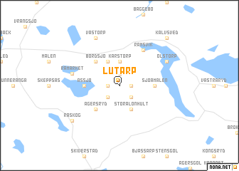
Lutarp (Jönköping, Sweden)Lutarp is a town in the Jönköping region of Sweden. An overview map of the region around Lutarp is displayed below.
regional and 3d topo map of Lutarp, Sweden ::
Lutarp airports ::
The nearest airport is JKG - Joenkoeping Jonkoping, located 56.6 km west of Lutarp.
Other airports nearby include HLF - Hultsfred (57.0 km south east), LPI - Linkoeping Saab (78.0 km north east), KVB - Skovde (95.5 km north west), VXO - Vaxjo Kronoberg (98.5 km south), Nearby towns ::
Konungsäng (1.0km east) //
Askeryd (1.0km west) //
Eldstorp (1.9km north) //
Djupadal (2.1km south east) //
Redeby (2.1km south west) //
Karstorp (3.7km north) //
Stora Lönhult (3.8km south) //
Hulu (3.8km north) //
Ägersryd (4.2km south west) //
Bordsjö (4.2km north west) //
Assjö (3.0km west) //
Sjöamålen (3.0km east) //
Liden (5.9km north) //
Ramsvik (5.9km north) //
Råmärket (4.4km north west) //
Olstorp (5.4km north east) //
Västorp (7.7km north) //
Råskog (6.8km south west) //
Kalvsved (8.4km north east) //
[all distances 'as the bird flies' and approximate] 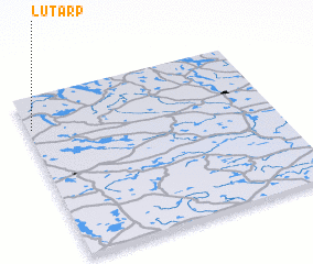 Places with similar names to Lutarp, Sweden ::
Disclaimer :: Information on this page comes without warranty of any kind |
||
|
Where is Lutarp? Elevation and coordinates ::
Latitude (lat): 57°48'0"N Longitude (lon): 15°1'0"E
Elevation (approx.): 236m (map arrows pan, magnifying glasses zoom) |
||
|
Visiting Lutarp? Hotel/Accommodation ::
Book a hotel in Lutarp Travel Guide ::
Buy a travel guide for Sweden rental cars ::
car rental offers GPS waypoint ::
download a GPX waypoint (PoI) of Lutarp for your GPS receiver
|
||