|
search place name
|
||
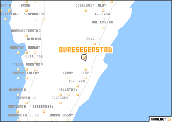
Övre Segerstad (Kalmar, Sweden)Övre Segerstad is a town in the Kalmar region of Sweden. An overview map of the region around Övre Segerstad is displayed below.
regional and 3d topo map of Övre Segerstad, Sweden ::
Övre Segerstad airports ::
The nearest airport is KLR - Kalkmar Kalmar, located 36.9 km north west of Övre Segerstad.
Other airports nearby include RNB - Ronneby (79.5 km west), OSK - Oskarshamn (107.7 km north), VXO - Vaxjo Kronoberg (126.3 km north west), HLF - Hultsfred (134.4 km north), Nearby towns ::
Nedre Segerstad (1.9km south) //
Mellby (1.9km north) //
Seby (3.7km south) //
Skärlöv (3.8km north) //
Träby (4.2km south west) //
Solberga (4.2km south west) //
Torngård (5.7km south) //
Gammalsby (7.5km south) //
Mellstaby (7.7km south) //
Hulterstad (7.7km north) //
Kvinnsgröta (8.0km south west) //
[all distances 'as the bird flies' and approximate] 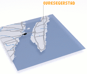 Places with similar names to Övre Segerstad, Sweden :: Disclaimer :: Information on this page comes without warranty of any kind |
||
|
Where is Övre Segerstad? Elevation and coordinates ::
Latitude (lat): 56°23'0"N Longitude (lon): 16°32'0"E
Elevation (approx.): 9m (map arrows pan, magnifying glasses zoom) |
||
|
Visiting Övre Segerstad? Hotel/Accommodation ::
Book a hotel in Övre Segerstad Travel Guide ::
Buy a travel guide for Sweden rental cars ::
car rental offers GPS waypoint ::
download a GPX waypoint (PoI) of Övre Segerstad for your GPS receiver
|
||