|
search place name
|
||
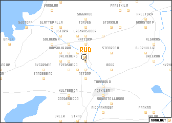
Rud ((( Älvsborg )), Sweden)Rud is a town in the (( Älvsborg )) region of Sweden. An overview map of the region around Rud is displayed below.
regional and 3d topo map of Rud, Sweden ::
Rud airports ::
The nearest airport is KVB - Skovde, located 35.3 km south of Rud.
Other airports nearby include LDK - Lidkoping (63.4 km south west), KSK - Karlskoga (68.4 km north), ORB - Orebro (74.2 km north east), LPI - Linkoeping Saab (100.3 km south east), Nearby towns ::
Brånäng (0.0km north) //
Äspäng (1.9km north) //
Slätteberg (1.9km south) //
Hajstorp (1.9km south) //
Sörby (1.9km south) //
Böckersboda (2.1km north west) //
Riksberg (2.1km south west) //
Mårby (2.1km south west) //
Håttorp (3.7km north) //
Valkeberg (1.9km west) //
Attorp (3.7km south) //
Höglunda (2.7km north west) //
Fredsberg (2.7km south west) //
Lyrestad (4.2km north west) //
Hult (5.6km north) //
Lagmansboda (5.6km north) //
Rävsnäs (2.9km west) //
Håsentorp (2.9km west) //
Horsklippan (3.4km north west) //
Stenåsen (3.4km north east) //
Fröåkra (5.6km north) //
Anderstorp (5.6km north) //
Boda (3.4km south east) //
Gastorp (5.9km north) //
Töreboda (5.9km south) //
Haddeboda (5.9km south) //
Torved (7.4km north) //
Älvstorp (6.3km north west) //
Solberga (5.3km north west) //
[all distances 'as the bird flies' and approximate] 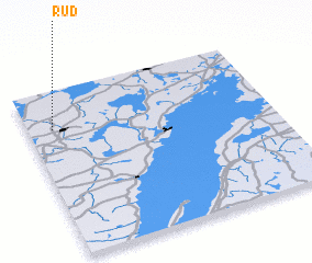 Places with similar names to Rud, Sweden ::
Disclaimer :: Information on this page comes without warranty of any kind |
||
|
Where is Rud? Elevation and coordinates ::
Latitude (lat): 58°46'0"N Longitude (lon): 14°6'0"E
Elevation (approx.): 93m (map arrows pan, magnifying glasses zoom) |
||
|
Visiting Rud? Hotel/Accommodation ::
Book a hotel in Rud Travel Guide ::
Buy a travel guide for Sweden rental cars ::
car rental offers GPS waypoint ::
download a GPX waypoint (PoI) of Rud for your GPS receiver
|
||