|
search place name
|
||
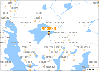
Snarkil (Värmland, Sweden)Snarkil is a town in the Värmland region of Sweden. An overview map of the region around Snarkil is displayed below.
regional and 3d topo map of Snarkil, Sweden ::
Snarkil airports ::
The nearest airport is LDK - Lidkoping, located 109.9 km south east of Snarkil.
Other airports nearby include THN - Trollhattan Vanersborg (113.2 km south), OSL - Oslo Gardermoen (116.1 km north west), KVB - Skovde (138.6 km south east), GSE - Gothenborg Save (175.1 km south), Nearby towns ::
Bryngelsbyn (2.1km south east) //
Svennebyn (1.9km east) //
Sanda (3.7km north) //
Guttebol (3.8km south) //
Kestad (2.6km north east) //
Karlsfors (4.2km south east) //
Älgtån (4.2km south east) //
Kålleboda (4.2km north east) //
Mölntegen (5.6km south) //
Hol (5.6km south) //
Sillerud (3.4km south east) //
Utängen (3.4km south east) //
Tobyn (5.9km south) //
Tenvik (5.9km north) //
Häljebyn (3.8km east) //
Signebyn (7.5km south) //
Trubbyn (4.2km south east) //
Litslerud (7.5km south) //
Åsebyn (6.2km north west) //
Bäcken (6.2km south east) //
Tokil (5.3km south west) //
Tjärn (7.7km north) //
Ed (7.9km south) //
Hult (8.3km south east) //
Västra Boda (8.3km south west) //
[all distances 'as the bird flies' and approximate]  Places with similar names to Snarkil, Sweden :: Disclaimer :: Information on this page comes without warranty of any kind |
||
|
Where is Snarkil? Elevation and coordinates ::
Latitude (lat): 59°20'0"N Longitude (lon): 12°16'0"E
Elevation (approx.): 154m (map arrows pan, magnifying glasses zoom) |
||
|
Visiting Snarkil? Hotel/Accommodation ::
Book a hotel in Snarkil Travel Guide ::
Buy a travel guide for Sweden rental cars ::
car rental offers GPS waypoint ::
download a GPX waypoint (PoI) of Snarkil for your GPS receiver
|
||