|
search place name
|
||
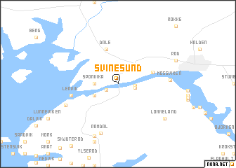
Svinesund ((( Älvsborg )), Sweden)Svinesund is a town in the (( Älvsborg )) region of Sweden. An overview map of the region around Svinesund is displayed below.
regional and 3d topo map of Svinesund, Sweden ::
nearby GPS traces from timatio ::
Svinesund airports ::
The nearest airport is TRF - Torp, located 58.5 km west of Svinesund.
Other airports nearby include SKE - Skien Geiteryggen (97.7 km west), THN - Trollhattan Vanersborg (107.2 km south east), OSL - Oslo Gardermoen (122.2 km north), LDK - Lidkoping (131.0 km south east), Nearby towns ::
Seläter (1.3km south west) //
Nedre Ringdalsstrand (1.5km east) //
Övre Ringdalsstrand (1.6km south east) //
Sponvika (1.9km west) //
Saltbacken (2.7km south west) //
Dale (5.6km north) //
Svarte-Jan (3.4km north east) //
Lervik (4.2km south west) //
Ramdal (8.0km south) //
Mossviken (4.3km east) //
Kålvik (5.5km south west) //
Hogdal (8.6km south) //
Lommeland (6.7km south east) //
[all distances 'as the bird flies' and approximate] 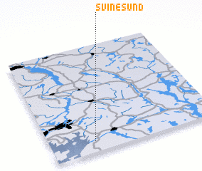 Places with similar names to Svinesund, Sweden ::
// Savannah Sound (BS)
// Svanesund (SE)
Disclaimer :: Information on this page comes without warranty of any kind |
||
|
Where is Svinesund? Elevation and coordinates ::
Latitude (lat): 59°6'0"N Longitude (lon): 11°16'0"E
Elevation (approx.): 61m (map arrows pan, magnifying glasses zoom) |
||
|
Visiting Svinesund? Hotel/Accommodation ::
Book a hotel in Svinesund Travel Guide ::
Buy a travel guide for Sweden rental cars ::
car rental offers GPS waypoint ::
download a GPX waypoint (PoI) of Svinesund for your GPS receiver
|
||