|
search place name
|
||
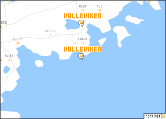
Valleviken (Gotland, Sweden)Valleviken is a town in the Gotland region of Sweden. An overview map of the region around Valleviken is displayed below.
regional and 3d topo map of Valleviken, Sweden ::
Valleviken airports ::
The nearest airport is VBY - Visby, located 36.5 km west of Valleviken.
Other airports nearby include BMA - Stockholm Bromma (191.6 km north), ARN - Stockholm Arlanda (223.7 km north), Nearby towns ::
Lörje (3.7km north) //
Kyllej (3.8km north) //
Valleviken (7.4km north) //
Hellvi (6.8km north west) //
[all distances 'as the bird flies' and approximate]  Places with similar names to Valleviken, Sweden ::
// Vallfogona (ES)
// Vieillevigne (FR)
// Vieillevigne (FR)
// Flavigny (FR)
// Valleviken (SE)
// Fleviken (SE)
// Vällviken (SE)
// Valviken (SE)
// Vieille-Vigne (FR)
// Velveken (BE)
Disclaimer :: Information on this page comes without warranty of any kind |
||
|
Where is Valleviken? Elevation and coordinates ::
Latitude (lat): 57°43'0"N Longitude (lon): 18°57'0"E
Elevation (approx.): -32768m (map arrows pan, magnifying glasses zoom) |
||
|
Visiting Valleviken? Hotel/Accommodation ::
Book a hotel in Valleviken Travel Guide ::
Buy a travel guide for Sweden rental cars ::
car rental offers GPS waypoint ::
download a GPX waypoint (PoI) of Valleviken for your GPS receiver
|
||