|
search place name
|
||
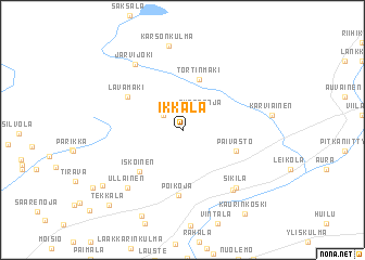
Ikkala (Länsi-Suomen Lääni, Finland)Ikkala is a town in the Länsi-Suomen Lääni region of Finland. An overview map of the region around Ikkala is displayed below.
regional and 3d topo map of Ikkala, Finland ::
Ikkala airports ::
The nearest airport is TKU - Turku, located 16.5 km south west of Ikkala.
Other airports nearby include POR - Pori (98.2 km north), TMP - Tampere Pirkkala (107.3 km north east), Nearby towns ::
Kaarlejoki (1.8km north west) //
Nunnanoja (2.1km north east) //
Tortinmäki (5.3km north) //
Päivästö (3.4km south east) //
Iskoinen (4.8km south west) //
Lavamäki (4.4km north west) //
Poikoja (6.7km south) //
Sikilä (6.4km south east) //
Leinakkala (6.6km south) //
Paattinen (6.5km south west) //
Ullainen (6.5km south west) //
Järvijoki (7.2km north) //
Karsonkulma (8.7km north) //
Pahkaanloukko (9.0km south) //
Uro (7.0km south west) //
Kaurinkoski (9.1km south) //
Tekkala (8.6km south west) //
[all distances 'as the bird flies' and approximate] 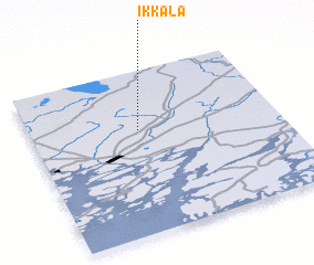 Places with similar names to Ikkala, Finland ::
Disclaimer :: Information on this page comes without warranty of any kind |
||
|
Where is Ikkala? Elevation and coordinates ::
Latitude (lat): 60°38'10"N Longitude (lon): 22°26'5"E
(map arrows pan, magnifying glasses zoom) |
||
|
Visiting Ikkala? Hotel/Accommodation ::
Book a hotel in Ikkala Travel Guide ::
Buy a travel guide for Finland rental cars ::
car rental offers GPS waypoint ::
download a GPX waypoint (PoI) of Ikkala for your GPS receiver
|
||