|
search place name
|
||
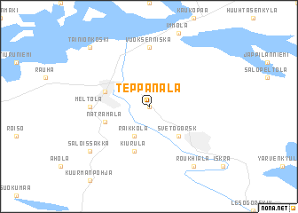
Teppanala (Etelä-Suomen Lääni, Finland)Teppanala is a town in the Etelä-Suomen Lääni region of Finland. An overview map of the region around Teppanala is displayed below.
regional and 3d topo map of Teppanala, Finland ::
Teppanala airports ::
The nearest airport is LPP - Lappeenranta, located 38.1 km west of Teppanala.
Other airports nearby include SVL - Savonlinna (88.6 km north), MIK - Mikkeli (104.9 km north west), QVY - Utti (105.4 km west), VRK - Varkaus (124.4 km north west), Nearby towns ::
Jakola (NaNkm north) //
Räikkölä (3.8km south) //
Svetogorsk (4.1km south east) //
Kiurula (5.6km south) //
Imatrankoski (3.3km north west) //
Imatra (3.3km north west) //
Näträmälä (3.3km south west) //
Vuoksenniska (7.4km north) //
Meltola (3.6km west) //
Salo-Issakka (6.6km south west) //
Roukhiala (7.9km south) //
Tainionkoski (8.2km north west) //
[all distances 'as the bird flies' and approximate] 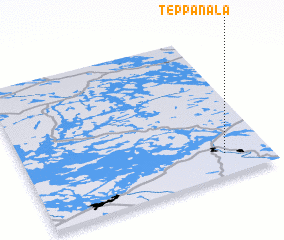 Places with similar names to Teppanala, Finland ::
Disclaimer :: Information on this page comes without warranty of any kind |
||
|
Where is Teppanala? Elevation and coordinates ::
Latitude (lat): 61°9'0"N Longitude (lon): 28°49'0"E
(map arrows pan, magnifying glasses zoom) |
||
|
Visiting Teppanala? Hotel/Accommodation ::
Book a hotel in Teppanala Travel Guide ::
Buy a travel guide for Finland rental cars ::
car rental offers GPS waypoint ::
download a GPX waypoint (PoI) of Teppanala for your GPS receiver
|
||