|
search place name
|
||
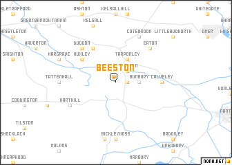
Beeston (United Kingdom)Beeston is a town in United Kingdom. An overview map of the region around Beeston is displayed below.
regional and 3d topo map of Beeston, United Kingdom ::
Beeston airports ::
The nearest airport is CEG - Hawarden, located 20.9 km west of Beeston.
Other airports nearby include LPL - Liverpool (26.6 km north west), MAN - Manchester (37.9 km north east), BLK - Blackpool (76.4 km north), EMA - Nottingham East Midlands (96.4 km east), Nearby towns ::
Spurstow (1.1km east) //
Tiverton (2.2km north east) //
Bunbury (2.2km east) //
Tarporley (3.9km north) //
Huxley (5.0km north west) //
Clotton (6.0km north) //
Calveley (4.4km east) //
Duddon (6.5km north west) //
Eaton (6.5km north east) //
Cote Brook (7.7km north) //
Harthill (5.8km south west) //
[all distances 'as the bird flies' and approximate]  Places with similar names to Beeston, United Kingdom ::
Disclaimer :: Information on this page comes without warranty of any kind |
||
|
Where is Beeston? Elevation and coordinates ::
Latitude (lat): 53°7'0"N Longitude (lon): 2°41'0"W
Elevation (approx.): 82m (map arrows pan, magnifying glasses zoom) |
||
|
Visiting Beeston? Hotel/Accommodation ::
Book a hotel in Beeston Travel Guide ::
rental cars ::
car rental offers GPS waypoint ::
download a GPX waypoint (PoI) of Beeston for your GPS receiver
|
||