|
search place name
|
||
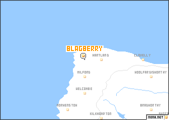
Blagberry (United Kingdom)Blagberry is a town in United Kingdom. An overview map of the region around Blagberry is displayed below.
regional and 3d topo map of Blagberry, United Kingdom ::
Blagberry airports ::
The nearest airport is PLH - Plymouth, located 70.5 km south east of Blagberry.
Other airports nearby include NQY - Newquai St Mawgan (70.8 km south west), SWS - Swansea (74.3 km north east), EXT - Exeter (83.1 km east), CWL - Cardiff (93.1 km north east), Nearby towns ::
 Places with similar names to Blagberry, United Kingdom ::
// Black Bear (US)
// Bālā Gabrī (IR)
// Black Bear (US)
// Blackberry (US)
// Blackberry (US)
// Blackberry (US)
// Bilgābbāri (BD)
// Balkabra (TD)
// Blackberry (US)
Disclaimer :: Information on this page comes without warranty of any kind |
||
|
Where is Blagberry? Elevation and coordinates ::
Latitude (lat): 51°0'0"N Longitude (lon): 4°31'0"W
Elevation (approx.): 96m (map arrows pan, magnifying glasses zoom) |
||
|
Visiting Blagberry? Hotel/Accommodation ::
Book a hotel in Blagberry Travel Guide ::
rental cars ::
car rental offers GPS waypoint ::
download a GPX waypoint (PoI) of Blagberry for your GPS receiver
|
||