|
search place name
|
||
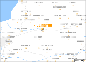
Hillington (United Kingdom)Hillington is a town in United Kingdom. An overview map of the region around Hillington is displayed below.
regional and 3d topo map of Hillington, United Kingdom ::
Hillington airports ::
The nearest airport is KNF - Marham, located 16.9 km south of Hillington.
Other airports nearby include MHZ - Mildenhall (49.0 km south), NWI - Norwich (50.3 km east), BEQ - Honington (52.8 km south), QCY - Coningsby (59.1 km north west), Nearby towns ::
Flitcham (0.0km north) //
Anmer (3.9km north) //
Grimston (3.9km south) //
Shernborne (5.7km north) //
Sandringham (5.0km north west) //
Gayton Thorpe (7.5km south) //
Gayton (7.5km south) //
Great Bircham (7.1km north east) //
Dersingham (7.1km north west) //
Ingoldisthorpe (8.1km north west) //
East Winch (8.7km south west) //
Snettisham (8.7km north west) //
[all distances 'as the bird flies' and approximate] 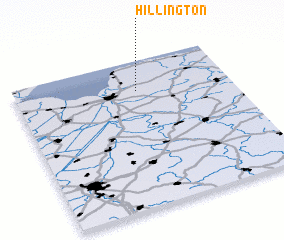 Places with similar names to Hillington, United Kingdom ::
// Hulington (US)
// Hillingdon (GB)
// Heilongdian (CN)
// Hualongtan (CN)
// Hallington (GB)
// Hillington (GB)
// Hollington (GB)
// Hollington (GB)
Disclaimer :: Information on this page comes without warranty of any kind |
||
|
Where is Hillington? Elevation and coordinates ::
Latitude (lat): 52°48'0"N Longitude (lon): 0°34'0"W
Elevation (approx.): 35m (map arrows pan, magnifying glasses zoom) |
||
|
Visiting Hillington? Hotel/Accommodation ::
Book a hotel in Hillington Travel Guide ::
rental cars ::
car rental offers GPS waypoint ::
download a GPX waypoint (PoI) of Hillington for your GPS receiver
|
||