|
search place name
|
||
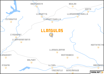
Llandulas (United Kingdom)Llandulas is a town in United Kingdom. An overview map of the region around Llandulas is displayed below.
regional and 3d topo map of Llandulas, United Kingdom ::
Llandulas airports ::
The nearest airport is SWS - Swansea, located 57.8 km south west of Llandulas.
Other airports nearby include CWL - Cardiff (75.4 km south), FZO - Bristol Filton (93.1 km south east), BRS - Bristol (97.5 km south east), GLO - Golouchestershire Gloucestershire (102.2 km east), Nearby towns ::
Llanwrtyd Wells (5.6km north) //
Llandeilor-Fan (5.7km south) //
Llanwrtyd (7.8km north) //
Pentre-bâch (8.2km south east) //
[all distances 'as the bird flies' and approximate]  Places with similar names to Llandulas, United Kingdom ::
// Llanetillos (MX)
// Llanetillos (HN)
// Landelles (FR)
// Lentilles (FR)
// Landelies (BE)
// Lentellais (ES)
// Lindelse (DK)
// Llanddulas (GB)
// Llanidloes (GB)
Disclaimer :: Information on this page comes without warranty of any kind |
||
|
Where is Llandulas? Elevation and coordinates ::
Latitude (lat): 52°3'0"N Longitude (lon): 3°38'0"W
Elevation (approx.): 262m (map arrows pan, magnifying glasses zoom) |
||
|
Visiting Llandulas? Hotel/Accommodation ::
Book a hotel in Llandulas Travel Guide ::
rental cars ::
car rental offers GPS waypoint ::
download a GPX waypoint (PoI) of Llandulas for your GPS receiver
|
||