|
search place name
|
||
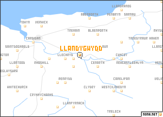
Llandygwydd (United Kingdom)Llandygwydd is a town in United Kingdom. An overview map of the region around Llandygwydd is displayed below.
regional and 3d topo map of Llandygwydd, United Kingdom ::
Llandygwydd airports ::
The nearest airport is SWS - Swansea, located 60.3 km south east of Llandygwydd.
Other airports nearby include CWL - Cardiff (111.5 km south east), BRS - Bristol (147.7 km south east), FZO - Bristol Filton (148.6 km south east), CEG - Hawarden (165.3 km north east), Nearby towns ::
Manordeifi (1.1km west) //
Newchapel (2.2km south west) //
Llechryd (2.3km west) //
Cenarth (2.9km south east) //
Pont Hirwaun (2.9km north east) //
Tremain (5.7km north) //
Penrydd (6.0km south) //
Blaenporth (6.0km north) //
Cilgerran (4.6km west) //
Brongwyn (4.6km east) //
Clydey (7.5km south) //
Boncath (6.5km south west) //
West Cilrhedyn (8.7km south east) //
[all distances 'as the bird flies' and approximate]  Places with similar names to Llandygwydd, United Kingdom ::
// Lunda Gate (ZA)
// Liande Kuta (ZM)
Disclaimer :: Information on this page comes without warranty of any kind |
||
|
Where is Llandygwydd? Elevation and coordinates ::
Latitude (lat): 52°3'0"N Longitude (lon): 4°34'0"W
Elevation (approx.): 49m (map arrows pan, magnifying glasses zoom) |
||
|
Visiting Llandygwydd? Hotel/Accommodation ::
Book a hotel in Llandygwydd Travel Guide ::
rental cars ::
car rental offers GPS waypoint ::
download a GPX waypoint (PoI) of Llandygwydd for your GPS receiver
|
||