|
search place name
|
||
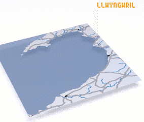
Llwyngwril (United Kingdom)Llwyngwril is a town in United Kingdom. An overview map of the region around Llwyngwril is displayed below.
regional and 3d topo map of Llwyngwril, United Kingdom ::

Llwyngwril airports ::
The nearest airport is CEG - Hawarden, located 93.6 km north east of Llwyngwril.
Other airports nearby include LPL - Liverpool (111.2 km north east), SWS - Swansea (118.1 km south), BLK - Blackpool (141.7 km north east), MAN - Manchester (143.5 km north east), Nearby towns ::
 Places with similar names to Llwyngwril, United Kingdom ::
// Langriāl (PK)
// Langriāl (PK)
// Langriāl (PK)
// Langriāl (PK)
// Lancarolla (PE)
// Langourala (ML)
// Langourla (FR)
// Langrolay (FR)
// Lenqueriel (GW)
Disclaimer :: Information on this page comes without warranty of any kind |
||
|
Where is Llwyngwril? Elevation and coordinates ::
Latitude (lat): 52°40'0"N Longitude (lon): 4°5'0"W
Elevation (approx.): 33m (map arrows pan, magnifying glasses zoom) |
||
|
Visiting Llwyngwril? Hotel/Accommodation ::
Book a hotel in Llwyngwril Travel Guide ::
rental cars ::
car rental offers GPS waypoint ::
download a GPX waypoint (PoI) of Llwyngwril for your GPS receiver
|
||