|
search place name
|
||
Portsmouth (United Kingdom)Portsmouth is a town in United Kingdom. An overview map of the region around Portsmouth is displayed below.
regional and 3d topo map of Portsmouth, United Kingdom ::

Portsmouth airports ::
The nearest airport is SOU - Southampton, located 28.1 km north west of Portsmouth.
Other airports nearby include QLA - Lasham (46.9 km north), ODH - Odiham (52.9 km north), BOH - Bournemouth (53.6 km west), ESH - Shoreham By Sea Shoreham (55.9 km east), Nearby towns ::
Southsea (2.2km north east) //
Eastney (3.0km north east) //
Seaview (5.7km south) //
Gosport (5.1km north west) //
Cosham (7.5km north) //
Hilsea (7.5km north) //
Alverstoke (5.0km west) //
Portchester (7.8km north) //
Brockhurst (6.0km north west) //
Saint Helens (7.8km south) //
[all distances 'as the bird flies' and approximate] 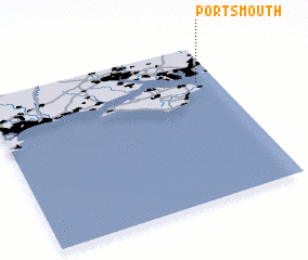 Places with similar names to Portsmouth, United Kingdom ::
// Port Smyth (ER)
// Portsmouth (US)
// Portsmouth (US)
// Portsmouth (US)
// Portsmouth (US)
// Portsmouth (US)
// Portsmouth (US)
// Portsmouth (DM)
// Portsmouth (CA)
// Portsmouth (US)
Disclaimer :: Information on this page comes without warranty of any kind |
||
|
Where is Portsmouth? Elevation and coordinates ::
Latitude (lat): 50°46'0"N Longitude (lon): 1°5'0"W
Elevation (approx.): -32768m (map arrows pan, magnifying glasses zoom) |
||
|
Visiting Portsmouth? Hotel/Accommodation ::
Book a hotel in Portsmouth Travel Guide ::
rental cars ::
car rental offers GPS waypoint ::
download a GPX waypoint (PoI) of Portsmouth for your GPS receiver
|
||