|
search place name
|
||
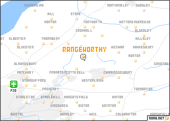
Rangeworthy (United Kingdom)Rangeworthy is a town in United Kingdom. An overview map of the region around Rangeworthy is displayed below.
regional and 3d topo map of Rangeworthy, United Kingdom ::
Rangeworthy airports ::
The nearest airport is FZO - Bristol Filton, located 11.1 km south west of Rangeworthy.
Other airports nearby include BRS - Bristol (27.7 km south west), LYE - Lyneham (32.4 km east), GLO - Golouchestershire Gloucestershire (41.3 km north east), FFD - Fairford (47.5 km east), Nearby towns ::
Iron Acton (2.2km south west) //
Tytherington (4.4km north west) //
Frampton Cotterell (4.4km south west) //
Yate (4.4km south east) //
Cromhall (5.6km north) //
Westerleigh (5.7km south) //
Charfield (6.0km north) //
Falfield (7.4km north) //
Tortworth (7.5km north) //
Wickwar (5.0km east) //
Thornbury (5.9km north west) //
Chipping Sodbury (5.9km south east) //
Morton (8.7km north west) //
Frenchay (8.7km south west) //
Hambrook (8.7km south west) //
[all distances 'as the bird flies' and approximate] 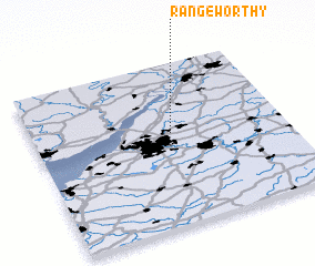 Places with similar names to Rangeworthy, United Kingdom :: Disclaimer :: Information on this page comes without warranty of any kind |
||
|
Where is Rangeworthy? Elevation and coordinates ::
Latitude (lat): 51°34'0"N Longitude (lon): 2°27'0"W
Elevation (approx.): 69m (map arrows pan, magnifying glasses zoom) |
||
|
Visiting Rangeworthy? Hotel/Accommodation ::
Book a hotel in Rangeworthy Travel Guide ::
rental cars ::
car rental offers GPS waypoint ::
download a GPX waypoint (PoI) of Rangeworthy for your GPS receiver
|
||